SHOP BY YEAR :: FOR OFFICE :: FOR CLASSROOM :: GIFT IDEAS :: CUSTOMER SERVICE

British Columbia Map 1992 Side 1
Issue: April 1992
More Views
Enlarge Image
ZoomClick here to zoom!
Purchase Product :
Please select map format:
Laminated   
27" x 20" - $39.95
Laminated-w/Plastic Rails  (What are rails?)
27" x 20" - $51.95
Paper
27" x 20" - $29.95
Wallzilla Adhesive Format
27" x 20" - $59.95
Product Highlights
British Columbia Map 1992 Side 1
Item#: X NGC 041992a

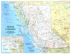
A land of rugged mountains and spectacular forests, British Columbia is a land of plentiful natural resources and vibrant native cultures. Part of the "Making of Canada" series, this map of the province is half of a two-map set published in April 1992. This map is noteworthy for its inclusion of the wealth of national and provincial parks, and Indian reserves in the region.

The 1992 British Columbia map Side 1 features:
• Inset map of southern Vancouver Island and the surrounding region
• National parks, provincial parks, and Indian reserves
• Historical notes
• Capitals, cities, and towns
• Mountains, passes, rivers, lakes, swamps, and glaciers or ice fields
• Limited access highways, roads, passenger railroads, canals, and scheduled air service
• Ocean bathymetry

Coverage Area: British Columbia, western Alberta, Alaskan panhandle

More Product Details

This map requires 7 business days to print and laminate prior to shipping.

Appearing in the April 1992 issue of the National Geographic Magazine, this British Columbia map has been reproduced from its original cartography in order to bring to life a beautiful poster previously only seen in National Geographic Magazine. This reproduction holds true to the high standards that National Geographic Maps are known for.

Perfect for home, office or classroom, this map also makes a great gift. Map collectors will surely want to add this map to their library.

The Paper version is printed on high quaility semi-gloss paper, perfect for framing.

The Laminated version uses 3mm laminate on both sides for durability, is easy to clean and markable.

From the National Geographic Classic Maps collection, this reproduction is just one of hundreds of titles available here. These maps are Printed on Demand. Sizes are approximate and may vary due to the nature of the trimming and laminating processes.
Shipping Conditions
Maps.com ships to Dometic US only

US FlagThis product can only be shipped to the Domestic U.S.A. (No APO's or PO Boxes)
TimeThis map requires 2 business days to print and laminate prior to shipping.