SHOP BY YEAR :: FOR OFFICE :: FOR CLASSROOM :: GIFT IDEAS :: CUSTOMER SERVICE

Canada Map 1936
Issue: June 1936
More Views
Enlarge Image
ZoomClick here to zoom!
Purchase Product :
Please select map format:
Laminated   
39" x 26.5" - $59.95
Laminated-w/Plastic Rails  (What are rails?)
39" x 26.5" - $76.95
Paper
39" x 26.5" - $49.95
Wallzilla Adhesive Format
39" x 26.5" - $89.95
Product Highlights
Canada Map 1936
Item#: X NGC 061936

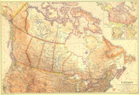
This stunning map is truly unique in the unusual pastel hues used to color the geographical regions. As informative as it is beautiful, this work features insets with details about Canadas climate, natural resources, as well as the routes of explorers. Published in June of 1936, it accompanied the article "Exploring Yukons Glacial Stronghold."

The 1936 Canada map features:
• Inset map showing natural resources, routes of explorers, and time zones
• The country broken down into natural regions including Pacific Highland, Great Interior Plain, Appalachian Highland, and Laurentian Upland
• Mean annual precipitation and temperature
• National capitals, state capitals, cities, and towns
• Highways, principal railways, canals, tunnels, and passes
• Principal ship routes with distances in nautical miles
• Geographical features including mountains, rivers, major lakes, intermittent streams, falls, swampy regions, and glaciers

Coverage Area: Canada, northern United States

More Product Details

This map requires 7 business days to print and laminate prior to shipping.

Appearing in the June 1936 issue of the National Geographic Magazine, this Canada map has been reproduced from its original cartography in order to bring to life a beautiful poster previously only seen in National Geographic Magazine. This reproduction holds true to the high standards that National Geographic Maps are known for.

Perfect for home, office or classroom, this map also makes a great gift. Map collectors will surely want to add this map to their library.

The Paper version is printed on high quaility semi-gloss paper, perfect for framing.

The Laminated version uses 3mm laminate on both sides for durability, is easy to clean and markable.

From the National Geographic Classic Maps collection, this reproduction is just one of hundreds of titles available here. These maps are Printed on Demand. Sizes are approximate and may vary due to the nature of the trimming and laminating processes.
Shipping Conditions
Maps.com ships to Dometic US only

US FlagThis product can only be shipped to the Domestic U.S.A. (No APO's or PO Boxes)
TimeThis map requires 2 business days to print and laminate prior to shipping.