SHOP BY YEAR :: FOR OFFICE :: FOR CLASSROOM :: GIFT IDEAS :: CUSTOMER SERVICE

Tidewater And Environs Map 1988 Side 2
Issue: June 1988
More Views
Enlarge Image
ZoomClick here to zoom!
Purchase Product :
Please select map format:
Laminated   
27" x 20" - $39.95
Laminated-w/Plastic Rails  (What are rails?)
27" x 20" - $51.95
Paper
27" x 20" - $29.95
Wallzilla Adhesive Format
27" x 20" - $59.95
Product Highlights
Tidewater And Environs Map 1988 Side 2
Item#: X NGC 061988b

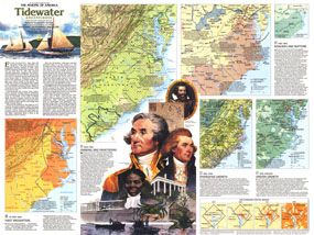
An area teeming with activity since the English settlement of Jamestown, the Tidewater region includes the Carolinas, Virginia, Maryland, Delaware, and the District of Columbia. The Tidewater and Environs map, published in June 1988, provides a wealth of historical information about this vital maritime region. Part of the "Making of America" series, this map represents Side Two in a two-piece set.

The 1988 Tidewater and Environs map Side 2 features:
• A historical introduction and colorful illustrations
• A map showing the region at the time of the arrival of the first Europeans including Indian culture areas, tribal groups, forts, land grants, and more
• Information and a map showing the frontier era of 1650-1783 with predominant agriculture, settlements, naval stores, roads, and more
• Information and maps showing the Civil War era with conflict sites, northern limits of slavery and cotton production, underground railroad routes, Virginia counties voting not to secede in 1861, and more
• A map of the region's growth with information on land use, agriculture, coal fields, mining, textiles, government facilities, and more
• A map highlighting the region's uneven growth since 1950 including urban centers, counties with significant out migration from 1950-1970, high-tech manufacturing, resorts, and more
• A series of 4 maps showing the changing Capital region from 1800-1986

Coverage Area: South Carolina, North Carolina, Virginia, West Virginia, Maryland, Delaware, District of Columbia

More Product Details

This map requires 7 business days to print and laminate prior to shipping.

Appearing in the June 1988 issue of the National Geographic Magazine, this Tidewater And Environs map Side 2 has been reproduced from its original cartography in order to bring to life a beautiful poster previously only seen in National Geographic Magazine. This reproduction holds true to the high standards that National Geographic Maps are known for.

Perfect for home, office or classroom, this map also makes a great gift. Map collectors will surely want to add this map to their library.

The Paper version is printed on high quaility semi-gloss paper, perfect for framing.

The Laminated version uses 3mm laminate on both sides for durability, is easy to clean and markable.

From the National Geographic Classic Maps collection, this reproduction is just one of hundreds of titles available here. These maps are Printed on Demand. Sizes are approximate and may vary due to the nature of the trimming and laminating processes.
Shipping Conditions
Maps.com ships to Dometic US only

US FlagThis product can only be shipped to the Domestic U.S.A. (No APO's or PO Boxes)
TimeThis map requires 2 business days to print and laminate prior to shipping.