 |
|
|
|
|
Ontario Map 1996 Side 2
Issue: June 1996
|
|
|
|
|
|
|
| Product Highlights |
| Ontario Map 1996 Side 2 |
| Item#: X NGC 061996b |
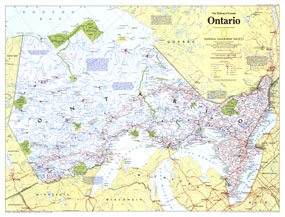
Published in June 1996, the Ontario map contains a wealth of information about this amazing province. The richest, most populous, and most urban province, Ontario is also a land of uninhabited wilderness and vast mineral wealth. Part of the "Making of Canada" series, this map represents Side Two of a two-map set. The 1996 Ontario map Side 2 features:
• A historical introduction
• A map of Ontario prior to 1600 showing tribal groups, explorers' routes, and trade routes with commodities
• A map of the region from 1600-1790 showing settled areas, fur trade routes, forts, trading posts, and more
• A map of the migration and expansion of the region which includes settlements, roads, canals, railroads, and sites related to the War of 1812
• A map highlighting the region's industry and resources including shipping, minerals, forest products, hydroelectric sites, manufacturing, and grain elevators
• A map of the region today showing land use, manufacturing districts, mining, nuclear power plants, pulp and paper mills, airports, and more
• Information on the various periods of Ontario's history
Coverage Area: Ontario
|
|
 |
More Product Details
This map requires 7 business days to print and laminate prior to shipping.
Appearing in the June 1996 issue of the National Geographic Magazine, this Ontario map Side 2 has been reproduced from its original cartography in order to bring to life a beautiful poster previously only seen in National Geographic Magazine. This reproduction holds true to the high standards that National Geographic Maps are known for.
Perfect for home, office or classroom, this map also makes a great gift. Map collectors will surely want to add this map to their library.
The Paper version is printed on high quaility semi-gloss paper, perfect for framing.
The Laminated version uses 3mm laminate on both sides for durability, is easy to clean and markable.
From the National Geographic Classic Maps collection, this reproduction is just one of hundreds of titles available here. These maps are Printed on Demand. Sizes are approximate and may vary due to the nature of the trimming and laminating processes.
|
|
Shipping Conditions
Maps.com ships to Dometic US only
 | This product can only be shipped to the Domestic U.S.A. (No APO's or PO Boxes) |  | This map requires 2 business days to print and laminate prior to shipping. |
|
|
|
|


 Click here to zoom!