 |
|
|
|
|
The North Map 1997
Issue: September 1997
|
|
|
|
|
|
|
| Product Highlights |
| The North Map 1997 |
| Item#: X NGC 091997b |
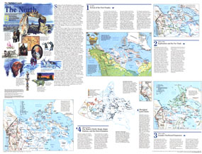
Explore the northernmost reaches of Canada with this educational map of The North. Published in September 1997 as part of the "Making of Canada" series, this map is a companion to the map of the Yukon and Northwest Territories printed in the same issue. Particular attention is paid to the history of the region's first inhabitants and the formation of the new province of Nunavut. The 1997 North map features:
• A map highlighting the region's early history with archaeological sites, tribal groups, and trade movement with commodities
• Information about the region's earliest inhabitants and archaeological finds
• Two maps of exploration and northward expansion (one highlighting the region from 1576-1870 and one from 1870-1939) showing explorers' routes, the northwest passage, North-West Mounted Police posts, missions, whaling stations, Hudson Bay Company posts, and more
• Inset map of the Klondike Gold Rush
• Information on aboriginal land claims with a map of the various tribes' holdings
• A modern map of the region detailing natural resources, pipelines, weather stations, and more
• An introduction to the Canadian north and colorful illustrations
Coverage Area: Yukon Territory, Northwest Territories
|
|
 |
More Product Details
This map requires 7 business days to print and laminate prior to shipping.
Appearing in the September 1997 issue of the National Geographic Magazine, this North map has been reproduced from its original cartography in order to bring to life a beautiful poster previously only seen in National Geographic Magazine. This reproduction holds true to the high standards that National Geographic Maps are known for.
Perfect for home, office or classroom, this map also makes a great gift. Map collectors will surely want to add this map to their library.
The Paper version is printed on high quaility semi-gloss paper, perfect for framing.
The Laminated version uses 3mm laminate on both sides for durability, is easy to clean and markable.
From the National Geographic Classic Maps collection, this reproduction is just one of hundreds of titles available here. These maps are Printed on Demand. Sizes are approximate and may vary due to the nature of the trimming and laminating processes.
|
|
Shipping Conditions
Maps.com ships to Dometic US only
 | This product can only be shipped to the Domestic U.S.A. (No APO's or PO Boxes) |  | This map requires 2 business days to print and laminate prior to shipping. |
|
|
|
|


 Click here to zoom!