SHOP BY YEAR :: FOR OFFICE :: FOR CLASSROOM :: GIFT IDEAS :: CUSTOMER SERVICE

Ancient Maya World Map 1989
Issue: October 1989
More Views
Enlarge Image
ZoomClick here to zoom!
Purchase Product :
Please select map format:
Laminated   
27" x 20" - $39.95
Laminated-w/Plastic Rails  (What are rails?)
27" x 20" - $51.95
Paper
27" x 20" - $29.95
Wallzilla Adhesive Format
27" x 20" - $59.95
Product Highlights
Ancient Maya World Map 1989
Item#: X NGC 101989b

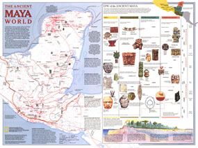
Explore the fascinating world of the Maya with this map published in October 1989. This map accompanied the "Land of the Maya" map in the same issue and three articles on the Maya including "La Ruta Maya." This work features an abundance of information about trade, travel, and the landscape of their civilization, including an explanation of the various eras of Maya history.

The 1989 Ancient Maya World map features:
• Sites officially recorded by archaelogical agencies
• Routes of the conquistadors
• Information on the Mayan landscape including geology, rainfall, and vegetation
• Sea trade routes, trade routes, sacbe (Maya causeway), and possible portage
• Trade goods including salt, shells, cacao, feathers, pottery, and obsidian
• Information on the eras of Maya history
• Illustrations and information about artifacts

Coverage Area: Guatemala, southern Mexico, Honduras, El Salvador

More Product Details

This map requires 7 business days to print and laminate prior to shipping.

Appearing in the October 1989 issue of the National Geographic Magazine, this Ancient Maya World map has been reproduced from its original cartography in order to bring to life a beautiful poster previously only seen in National Geographic Magazine. This reproduction holds true to the high standards that National Geographic Maps are known for.

Perfect for home, office or classroom, this map also makes a great gift. Map collectors will surely want to add this map to their library.

The Paper version is printed on high quaility semi-gloss paper, perfect for framing.

The Laminated version uses 3mm laminate on both sides for durability, is easy to clean and markable.

From the National Geographic Classic Maps collection, this reproduction is just one of hundreds of titles available here. These maps are Printed on Demand. Sizes are approximate and may vary due to the nature of the trimming and laminating processes.
Shipping Conditions
Maps.com ships to Dometic US only

US FlagThis product can only be shipped to the Domestic U.S.A. (No APO's or PO Boxes)
TimeThis map requires 2 business days to print and laminate prior to shipping.