SHOP BY YEAR :: FOR OFFICE :: FOR CLASSROOM :: GIFT IDEAS :: CUSTOMER SERVICE

Mexico, Central America And The West Indies Map 1934
Issue: December 1934
More Views
Enlarge Image
ZoomClick here to zoom!
Purchase Product :
Please select map format:
Laminated   
40" x 24" - $59.95
Laminated-w/Plastic Rails  (What are rails?)
40" x 24" - $76.95
Paper
40" x 24" - $49.95
Wallzilla Adhesive Format
40" x 24" - $89.95
Product Highlights
Mexico, Central America And The West Indies Map 1934
Item#: X NGC 121934

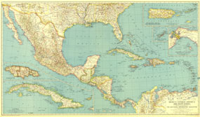
Published in December 1934, this map of Mexico, Central America and the West Indies accompanied three articles on Mexico and the West Indies including "Hunting Useful Plants in the Caribbean." Broad in its scope of the region, this map includes inset maps of the isthmus of Panama and several major islands.

The 1934 Mexico, Central America and the West Indies map features:
• Inset maps of Puerto Rico and the Virgin Islands, the Bermuda Islands, Jamaica, and Cuba
• Inset map of the Isthmus of Panama
• Capitals of countries, other capitals, cities, and towns
• Inter-American highway (under construction or projected), highways, railways, and canals
• Mountain relief, rivers, lakes, and swamps
• Ruins

Coverage Area: Mexico, Central America, West Indies, Bahama Islands, southern United States, northern Columbia, northern Venezuela

More Product Details

This map requires 7 business days to print and laminate prior to shipping.

Appearing in the December 1934 issue of the National Geographic Magazine, this Mexico, Central America And The West Indies map has been reproduced from its original cartography in order to bring to life a beautiful poster previously only seen in National Geographic Magazine. This reproduction holds true to the high standards that National Geographic Maps are known for.

Perfect for home, office or classroom, this map also makes a great gift. Map collectors will surely want to add this map to their library.

The Paper version is printed on high quaility semi-gloss paper, perfect for framing.

The Laminated version uses 3mm laminate on both sides for durability, is easy to clean and markable.

From the National Geographic Classic Maps collection, this reproduction is just one of hundreds of titles available here. These maps are Printed on Demand. Sizes are approximate and may vary due to the nature of the trimming and laminating processes.
Shipping Conditions
Maps.com ships to Dometic US only

US FlagThis product can only be shipped to the Domestic U.S.A. (No APO's or PO Boxes)
TimeThis map requires 2 business days to print and laminate prior to shipping.