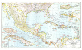
The map of Mexico, Central America and the West Indies published in National Geographic Magazine in December 1939 accompanied the article "Puerto Rico: Watchdog of the Caribbean." A wealth of historical notes dot this map, including the dates of the the founding of many cities, the explorers who named them, Aztec and Maya sites, and more. The 1939 Mexico, Central America and the West Indies map features:
• Inset maps of Puerto Rico and the Virgin Islands, Saint Thomas, the Bermuda Islands, Jamaica, and Cuba
• Inset map of the Isthmus of Panama
• Historical notes
• Capitals of countries, other capitals, cities, and towns
• Inter-American highway (under construction or projected), highways, railways, and canals
• Mountain relief, rivers, lakes, swamps, ruins, and areas subject to inundation
• Geographical equivalents
Coverage Area: Mexico, Central America, West Indies, Bahama Islands, southern United States, northern Columbia, northern Venezuela
|


 Click here to zoom!
