SHOP BY YEAR :: FOR OFFICE :: FOR CLASSROOM :: GIFT IDEAS :: CUSTOMER SERVICE

West Indies Map 1962
Issue: December 1962
More Views
Enlarge Image
ZoomClick here to zoom!
Purchase Product :
Please select map format:
Laminated   
25" x 19" - $19.95
Laminated-w/Plastic Rails  (What are rails?)
25" x 19" - $29.95
Paper
25" x 19" - $14.95
Wallzilla Adhesive Format
25" x 19" - $34.95
Product Highlights
West Indies Map 1962
Item#: X NGC 121962

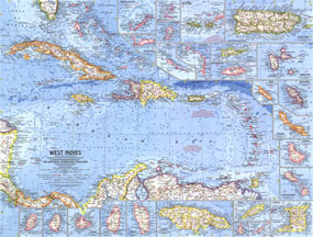
Operation Bootstrap was the name given to ambitious projects which rapidly industrialized Puerto Rico in the 1950s, shifting the region's economy from agriculture to manufacturing. The article "Puerto Rico's Seven-league Bootstraps" accompanied this map of the West Indies in the December 1962 issue of National Geographic Magazine. This colorful and detailed work of cartography features inset maps of over two dozen islands as well as ocean bathymetry, currents, and prevailing winds.

The 1962 West Indies map features:
• Insets of over two dozen islands
• Capitals, cities, and towns
• Pan-American highway system, freeways, roads, railroads, canals, and places with scheduled air service
• Ocean bathymetry, prevailing winds, and warm currents
• Political administration of islands noted
• Missile tracking stations
• Oil fields and pipelines

Coverage Area: West Indies, Panama, Costa Rica, northern Columbia, northern Venezuela

More Product Details

This map requires 7 business days to print and laminate prior to shipping.

Appearing in the December 1962 issue of the National Geographic Magazine, this West Indies map has been reproduced from its original cartography in order to bring to life a beautiful poster previously only seen in National Geographic Magazine. This reproduction holds true to the high standards that National Geographic Maps are known for.

Perfect for home, office or classroom, this map also makes a great gift. Map collectors will surely want to add this map to their library.

The Paper version is printed on high quaility semi-gloss paper, perfect for framing.

The Laminated version uses 3mm laminate on both sides for durability, is easy to clean and markable.

From the National Geographic Classic Maps collection, this reproduction is just one of hundreds of titles available here. These maps are Printed on Demand. Sizes are approximate and may vary due to the nature of the trimming and laminating processes.
Shipping Conditions
Maps.com ships to Dometic US only

US FlagThis product can only be shipped to the Domestic U.S.A. (No APO's or PO Boxes)
TimeThis map requires 2 business days to print and laminate prior to shipping.