SHOP BY YEAR :: FOR OFFICE :: FOR CLASSROOM :: GIFT IDEAS :: CUSTOMER SERVICE

Theater Of War In The Pacific Ocean Map 1942
Issue: February 1942
More Views
Enlarge Image
ZoomClick here to zoom!
Purchase Product :
Please select map format:
Laminated   
27" x 21" - $39.95
Laminated-w/Plastic Rails  (What are rails?)
27" x 21" - $51.95
Paper
27" x 21" - $29.95
Wallzilla Adhesive Format
27" x 21" - $59.95
Product Highlights
Theater Of War In The Pacific Ocean Map 1942
Item#: X NGC 021942

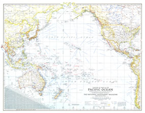
An exceptional historical piece, this map was published in February 1942 with an article entitled "Facts about the Philippines." Time zones, ship routes, and naval bases, make this a valuable map for collectors and those interested in World War II.

The 1942 Theater of War in the Pacific Ocean map features:
• Time zone boundaries and clocks showing the time when it is midnight in Greenwich
• An abundance of place names including country capitals, other capitals, cities, and towns
• Inset showing airline distances in statute miles
• Railways and principal ship routes showing distances in nautical miles
• Naval bases
• Geographical features including reefs, mountains, swampy regions, and glaciers

Coverage Area: North America, western Central and South America, Australia, New Zealand, eastern Asia

More Product Details

This map requires 7 business days to print and laminate prior to shipping.

Appearing in the February 1942 issue of the National Geographic Magazine, this Theater Of War In The Pacific Ocean map has been reproduced from its original cartography in order to bring to life a beautiful poster previously only seen in National Geographic Magazine. This reproduction holds true to the high standards that National Geographic Maps are known for.

Perfect for home, office or classroom, this map also makes a great gift. Map collectors will surely want to add this map to their library.

The Paper version is printed on high quaility semi-gloss paper, perfect for framing.

The Laminated version uses 3mm laminate on both sides for durability, is easy to clean and markable.

From the National Geographic Classic Maps collection, this reproduction is just one of hundreds of titles available here. These maps are Printed on Demand. Sizes are approximate and may vary due to the nature of the trimming and laminating processes.
Shipping Conditions
Maps.com ships to Dometic US only

US FlagThis product can only be shipped to the Domestic U.S.A. (No APO's or PO Boxes)
TimeThis map requires 2 business days to print and laminate prior to shipping.