 |
|
|
|
|
Pacific Islands Map 1962
Issue: April 1962
|
|
|
|
|
|
|
| Product Highlights |
| Pacific Islands Map 1962 |
| Item#: X NGC 041962a |
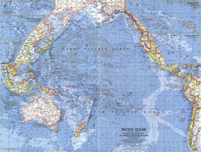
Published in April 1962 in conjunction with a map of the Pacific and an article on New Zealand, this work features inset maps of fifty islands and island groups. Vivid ocean bathymetry and reef detail combined with geographical relief bring these islands to life. The 1962 New Zealand, New Guinea and the Principal Pacific Islands map features:
• Inset maps of fifty islands and island groups including New Zealand, New Guinea, the Solomon Islands, Guam, Okinawa, and more
• Capitals, cities, and towns
• Ocean bathymetry and reefs
• Roads and places with scheduled air service
• National parks
• Political administration
Coverage Area: New Zealand, New Guinea, principal Pacific Islands
|
|
 |
More Product Details
This map requires 7 business days to print and laminate prior to shipping.
Appearing in the April 1962 issue of the National Geographic Magazine, this New Zealand, New Guinea And The Principal Pacific Islands map has been reproduced from its original cartography in order to bring to life a beautiful poster previously only seen in National Geographic Magazine. This reproduction holds true to the high standards that National Geographic Maps are known for.
Perfect for home, office or classroom, this map also makes a great gift. Map collectors will surely want to add this map to their library.
The Paper version is printed on high quaility semi-gloss paper, perfect for framing.
The Laminated version uses 3mm laminate on both sides for durability, is easy to clean and markable.
From the National Geographic Classic Maps collection, this reproduction is just one of hundreds of titles available here. These maps are Printed on Demand. Sizes are approximate and may vary due to the nature of the trimming and laminating processes.
|
|
Shipping Conditions
Maps.com ships to Dometic US only
 | This product can only be shipped to the Domestic U.S.A. (No APO's or PO Boxes) |  | This map requires 2 business days to print and laminate prior to shipping. |
|
|
|
|


 Click here to zoom!