SHOP BY YEAR :: FOR OFFICE :: FOR CLASSROOM :: GIFT IDEAS :: CUSTOMER SERVICE

Atlantic Ocean Floor Map 1968
Issue: June 1968
More Views
Enlarge Image
ZoomClick here to zoom!
Purchase Product :
Please select map format:
Laminated   
19" x 25" - $19.95
Laminated-w/Plastic Rails  (What are rails?)
19" x 25" - $29.95
Paper
19" x 25" - $14.95
Wallzilla Adhesive Format
19" x 25" - $34.95
Product Highlights
Atlantic Ocean Floor Map 1968
Item#: X NGC 061968b

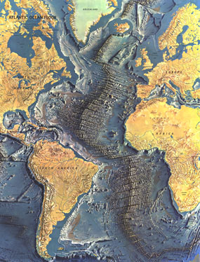
This distinctive physical map of the Atlantic Ocean floor appeared in the June 1968 issue of National Geographic as a supplement to the map of the Atlantic. The detail of such submarine terrain as continental slopes, abyssal plains, and the mighty Mid-Atlantic Ridge is stunning. A true work of art, and a wonderful companion to the ocean floor maps of the Indian (1967), Pacific (1969), and Arctic (1971).

The 1968 Atlantic Ocean Floor map features:
• Land masses and the ocean floor illustrated in stunning relief
• Ocean depths noted
• Names of submarine terrain as well as major geographic regions

Coverage Area: Atlantic Ocean, Mediterranean Sea, southeastern Pacific Ocean

More Product Details

This map requires 7 business days to print and laminate prior to shipping.

Appearing in the June 1968 issue of the National Geographic Magazine, this Atlantic Ocean Floor map has been reproduced from its original cartography in order to bring to life a beautiful poster previously only seen in National Geographic Magazine. This reproduction holds true to the high standards that National Geographic Maps are known for.

Perfect for home, office or classroom, this map also makes a great gift. Map collectors will surely want to add this map to their library.

The Paper version is printed on high quaility semi-gloss paper, perfect for framing.

The Laminated version uses 3mm laminate on both sides for durability, is easy to clean and markable.

From the National Geographic Classic Maps collection, this reproduction is just one of hundreds of titles available here. These maps are Printed on Demand. Sizes are approximate and may vary due to the nature of the trimming and laminating processes.
Shipping Conditions
Maps.com ships to Dometic US only

US FlagThis product can only be shipped to the Domestic U.S.A. (No APO's or PO Boxes)
TimeThis map requires 2 business days to print and laminate prior to shipping.