SHOP BY YEAR :: FOR OFFICE :: FOR CLASSROOM :: GIFT IDEAS :: CUSTOMER SERVICE

Pacific Ocean Map 1969
Issue: October 1969
More Views
Enlarge Image
ZoomClick here to zoom!
Purchase Product :
Please select map format:
Laminated   
25" x 19" - $19.95
Laminated-w/Plastic Rails  (What are rails?)
25" x 19" - $29.95
Paper
25" x 19" - $14.95
Wallzilla Adhesive Format
25" x 19" - $34.95
Product Highlights
Pacific Ocean Map 1969
Item#: X NGC 101969a

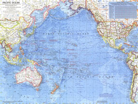
This detailed map of the Pacific Ocean published in October 1969 includes a wealth of historical notes including the splashdown points of the Appollo missions in 1968 and 1969. Also printed in the same issue was a map of the Pacific Ocean floor. Both Pacific maps are wonderful companions to the two similar maps of the Atlantic published in 1968 and the Arctic maps of 1971.

The 1969 Pacific Ocean map features:
• An abundance of historical and geographical notes
• Ocean bathymetry, prevailing winds, and currents
• Controlling channel depths in feet for principal ports
• Distances across the Pacific
• Geographical features such as mountain ranges, major lakes, major rivers, glaciers, deserts, and coral reefs
• Place names including capitals, cities, and towns
• Principal airports and canals

Coverage Area: Pacific Ocean, western North America, western South America, eastern Asia, Australia, New Zealand

More Product Details

This map requires 7 business days to print and laminate prior to shipping.

Appearing in the October 1969 issue of the National Geographic Magazine, this Pacific Ocean map has been reproduced from its original cartography in order to bring to life a beautiful poster previously only seen in National Geographic Magazine. This reproduction holds true to the high standards that National Geographic Maps are known for.

Perfect for home, office or classroom, this map also makes a great gift. Map collectors will surely want to add this map to their library.

The Paper version is printed on high quaility semi-gloss paper, perfect for framing.

The Laminated version uses 3mm laminate on both sides for durability, is easy to clean and markable.

From the National Geographic Classic Maps collection, this reproduction is just one of hundreds of titles available here. These maps are Printed on Demand. Sizes are approximate and may vary due to the nature of the trimming and laminating processes.
Shipping Conditions
Maps.com ships to Dometic US only

US FlagThis product can only be shipped to the Domestic U.S.A. (No APO's or PO Boxes)
TimeThis map requires 2 business days to print and laminate prior to shipping.