SHOP BY YEAR :: FOR OFFICE :: FOR CLASSROOM :: GIFT IDEAS :: CUSTOMER SERVICE

Eastern South America Map 1955
Issue: March 1955
More Views
Enlarge Image
ZoomClick here to zoom!
Purchase Product :
Please select map format:
Laminated   
29" x 40" - $59.95
Laminated-w/Plastic Rails  (What are rails?)
29" x 40" - $76.95
Paper
29" x 40" - $49.95
Wallzilla Adhesive Format
29" x 40" - $89.95
Product Highlights
Eastern South America Map 1955
Item#: X NGC 031955

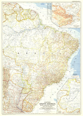
The Eastern South America map was published in March 1955 with two articles on the region including "Spectacular Rio de Janeiro" and "Life Among the Wai Wai Indians." Of particular note on this map is the inset of Rio de Janeiro. A fine companion to the map of Southern South America printed in 1958.

The 1955 Eastern South America map features:
• Inset map of Rio de Janeiro
• Capitals, cities, and towns
• Mountain relief, rivers, and lakes
• Pan American Highway, railways, roads, and airports
• Oil fields and pipelines
• Geographical equivalents
• Depth curves and soundings in fathoms, elevations in feet

Coverage Area: Brazil, British Guiana, Surinam (Dutch Guiana), French Guiana, Bolivia, Paraguay, Uraguay, northern Argentina

More Product Details

This map requires 7 business days to print and laminate prior to shipping.

Appearing in the March 1955 issue of the National Geographic Magazine, this Eastern South America map has been reproduced from its original cartography in order to bring to life a beautiful poster previously only seen in National Geographic Magazine. This reproduction holds true to the high standards that National Geographic Maps are known for.

Perfect for home, office or classroom, this map also makes a great gift. Map collectors will surely want to add this map to their library.

The Paper version is printed on high quaility semi-gloss paper, perfect for framing.

The Laminated version uses 3mm laminate on both sides for durability, is easy to clean and markable.

From the National Geographic Classic Maps collection, this reproduction is just one of hundreds of titles available here. These maps are Printed on Demand. Sizes are approximate and may vary due to the nature of the trimming and laminating processes.
Shipping Conditions
Maps.com ships to Dometic US only

US FlagThis product can only be shipped to the Domestic U.S.A. (No APO's or PO Boxes)
TimeThis map requires 2 business days to print and laminate prior to shipping.