 |
|
|
|
|
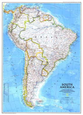
South America Map 1992
Issue: August 1992
|
|
|
|
|
|
|
| Product Highlights |
| South America Map 1992 |
| Item#: X NGC 081992a |
At the time of this maps creation in August 1992, only one country in South America was not an independent nation; French Guiana remains part of France and hosts the European Space Agencys principal spaceport, the Centre Spatial Guyanais. This map is the perfect companion for the supplemental map "Amazonia, A World Resource At Risk" which was printed in the same issue. The 1992 South America map features:
• Ocean bathymetry and currents
• Geographical features including mountains, rivers, lakes, dry lakes, intermittent lakes, and glaciers
• Colorful and distinctive country borders
• Thousands of place names including capitals, cities, and towns
• Railroads, roads, roads under construction, and scheduled air service
• Oil fields and pipelines
• Ruins
Coverage Area: South America
|
|
 |
More Product Details
This map requires 7 business days to print and laminate prior to shipping.
Appearing in the August 1992 issue of the National Geographic Magazine, this South America map has been reproduced from its original cartography in order to bring to life a beautiful poster previously only seen in National Geographic Magazine. This reproduction holds true to the high standards that National Geographic Maps are known for.
Perfect for home, office or classroom, this map also makes a great gift. Map collectors will surely want to add this map to their library.
The Paper version is printed on high quaility semi-gloss paper, perfect for framing.
The Laminated version uses 3mm laminate on both sides for durability, is easy to clean and markable.
From the National Geographic Classic Maps collection, this reproduction is just one of hundreds of titles available here. These maps are Printed on Demand. Sizes are approximate and may vary due to the nature of the trimming and laminating processes.
|
|
Shipping Conditions
Maps.com ships to Dometic US only
 | This product can only be shipped to the Domestic U.S.A. (No APO's or PO Boxes) |  | This map requires 2 business days to print and laminate prior to shipping. |
|
|
|
|


 Click here to zoom!