 |
|
|
|
|
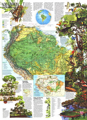
Amazonia, A World Resource At Risk Map 1992
Issue: August 1992
|
|
|
|
|
|
|
| Product Highlights |
| Amazonia, A World Resource At Risk Map 1992 |
| Item#: X NGC 081992b |
With a physical map of the Amazon basin as well as an abundance of illustrations and information about this magnificent region, this map is a must-have for those fascinated by the beauty and mystery of the tropical rainforest. Discover how this regions health affects the health of the entire planet and the threats facing it. Published in August 1992, it is a perfect companion for the political map of South America printed in the same issue. The 1992 "Amazonia, A World Resource At Risk" map features:
• A physical and political map of the Amazon basin
• An abundance of information on the Amazonian ecosystem and the various ways its health affects the overall health of the planet
• Inset showing the atmospheric circulation of winds
• Selected industry and land use within the Amazon basin
• Stunning illustrations of the flora and fauna of the Amazon rainforests
• Transportation and additional sites of importance
• Information on the threats facing this remarkable region of the world
Coverage Area: Amazon basin
|
|
 |
More Product Details
This map requires 7 business days to print and laminate prior to shipping.
Appearing in the August 1992 issue of the National Geographic Magazine, this Amazonia, A World Resource At Risk map has been reproduced from its original cartography in order to bring to life a beautiful poster previously only seen in National Geographic Magazine. This reproduction holds true to the high standards that National Geographic Maps are known for.
Perfect for home, office or classroom, this map also makes a great gift. Map collectors will surely want to add this map to their library.
The Paper version is printed on high quaility semi-gloss paper, perfect for framing.
The Laminated version uses 3mm laminate on both sides for durability, is easy to clean and markable.
From the National Geographic Classic Maps collection, this reproduction is just one of hundreds of titles available here. These maps are Printed on Demand. Sizes are approximate and may vary due to the nature of the trimming and laminating processes.
|
|
Shipping Conditions
Maps.com ships to Dometic US only
 | This product can only be shipped to the Domestic U.S.A. (No APO's or PO Boxes) |  | This map requires 2 business days to print and laminate prior to shipping. |
|
|
|
|


 Click here to zoom!