 |
|
|
|
|
South America Map 1950
Issue: October 1950
|
|
|
|
|
|
|
| Product Highlights |
| South America Map 1950 |
| Item#: X NGC 101950 |
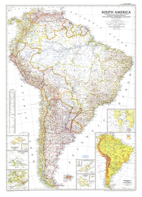
Published in October 1950 with three articles including "Peru, Homeland of the Warlike Inca," this map of South America is the first to show airports on the continent. Land transportation was growing as well at this time, as evidenced by the roads and railways under construction. The 1950 South America map features:
• A physical map of the continent
• Inset maps of Trinidad, Fernando de Noronha, the Galapagos Islands, Easter Island, and the Canal Zone
• Location of South America in the Western World
• Thousands of place names including cities, and towns
• Railways, roads, Pan American Highway, and important airports
• Oil pipelines and oil fields
• Geographical equivalents and abbreviations
Coverage Area: South America
|
|
 |
More Product Details
This map requires 7 business days to print and laminate prior to shipping.
Appearing in the October 1950 issue of the National Geographic Magazine, this South America map has been reproduced from its original cartography in order to bring to life a beautiful poster previously only seen in National Geographic Magazine. This reproduction holds true to the high standards that National Geographic Maps are known for.
Perfect for home, office or classroom, this map also makes a great gift. Map collectors will surely want to add this map to their library.
The Paper version is printed on high quaility semi-gloss paper, perfect for framing.
The Laminated version uses 3mm laminate on both sides for durability, is easy to clean and markable.
From the National Geographic Classic Maps collection, this reproduction is just one of hundreds of titles available here. These maps are Printed on Demand. Sizes are approximate and may vary due to the nature of the trimming and laminating processes.
|
|
Shipping Conditions
Maps.com ships to Dometic US only
 | This product can only be shipped to the Domestic U.S.A. (No APO's or PO Boxes) |  | This map requires 2 business days to print and laminate prior to shipping. |
|
|
|
|


 Click here to zoom!