 |
|
|
|
|
Red Planet Mars Map 1973
Issue: February 1973
|
|
|
|
|
|
|
| Product Highlights |
| Red Planet Mars Map 1973 |
| Item#: X NGC 021973a |
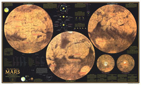
Explore the Red Planet in striking detail with this educational map published in February 1973. This map was half of a two-part piece, appearing with a complete index map entitled "The Dusty Face of Mars" and two additional articles on Mars: "Journey to Mars" and "The Search for Life on Mars." Featuring detailed illustrations of Mars from different angles, this map also contains an abundance of illustrations and information about the planets physical attributes including atmosphere, surface color, magnetic field, winds, and temperature. The 1973 Red Planet Mars map features:
• Maps of three views of Mars including Central Meridian 0 degrees, 120 degrees, and 240 degrees
• Maps of the North Pole and South Pole regions
• Illustrations and information on the seasons on Mars
• Measurements comparison to Earth
• Illustrations explaining retrograde and conjunction
• Mars place in the solar system
• An assortment of facts about the Red Planet including surface color, polar caps, atmosphere, clouds, winds, temperature, weight, and magnetic field
Coverage Area: Mars
|
|
 |
More Product Details
This map requires 7 business days to print and laminate prior to shipping.
Appearing in the February 1973 issue of the National Geographic Magazine, this Red Planet Mars map has been reproduced from its original cartography in order to bring to life a beautiful poster previously only seen in National Geographic Magazine. This reproduction holds true to the high standards that National Geographic Maps are known for.
Perfect for home, office or classroom, this map also makes a great gift. Map collectors will surely want to add this map to their library.
The Paper version is printed on high quaility semi-gloss paper, perfect for framing.
The Laminated version uses 3mm laminate on both sides for durability, is easy to clean and markable.
From the National Geographic Classic Maps collection, this reproduction is just one of hundreds of titles available here. These maps are Printed on Demand. Sizes are approximate and may vary due to the nature of the trimming and laminating processes.
|
|
Shipping Conditions
Maps.com ships to Dometic US only
 | This product can only be shipped to the Domestic U.S.A. (No APO's or PO Boxes) |  | This map requires 2 business days to print and laminate prior to shipping. |
|
|
|
|


 Click here to zoom!