 |
|
|
|
|
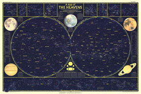
Heavens Map 1957 Side 1
Issue: December 1957
|
|
|
|
|
|
|
| Product Highlights |
| Heavens Map 1957 Side 1 |
| Item#: X NGC 121957a |
Published in December 1957, this map is half of a two-part map of the heavens that appeared with the article "How Man-made Satellites Can Affect Our Lives." It shows the constellations and brightest stars as seen from both the northern and southern hemispheres and also includes information on the planets including their relative size. The 1957 Heavens map side 1 features:
• The northern sky and its constellations
• The southern sky and its constellations
• Where to look for the planets: 1958-1961
• Illustrations of 88 constellations, and illustrations and information about the Earth, the Moon, Mars, Jupiter, and Saturn
• Relative size of the planets
• The Zodiac: Path of the Sun and Planets the year round
Coverage Area: Space
|
|
 |
More Product Details
This map requires 7 business days to print and laminate prior to shipping.
Appearing in the December 1957 issue of the National Geographic Magazine, this Heavens map has been reproduced from its original cartography in order to bring to life a beautiful poster previously only seen in National Geographic Magazine. This reproduction holds true to the high standards that National Geographic Maps are known for.
Perfect for home, office or classroom, this map also makes a great gift. Map collectors will surely want to add this map to their library.
The Paper version is printed on high quaility semi-gloss paper, perfect for framing.
The Laminated version uses 3mm laminate on both sides for durability, is easy to clean and markable.
From the National Geographic Classic Maps collection, this reproduction is just one of hundreds of titles available here. These maps are Printed on Demand. Sizes are approximate and may vary due to the nature of the trimming and laminating processes.
|
|
Shipping Conditions
Maps.com ships to Dometic US only
 | This product can only be shipped to the Domestic U.S.A. (No APO's or PO Boxes) |  | This map requires 2 business days to print and laminate prior to shipping. |
|
|
|
|


 Click here to zoom!