|
|
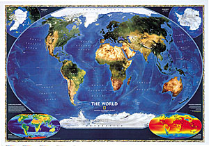
National Geographic World Satellite Wall Map
Issue:

|
|
|
|
|
|
|
| Product Highlights |
| National Geographic World Satellite Wall Map |
| Item#: NG WOR SATELLITE |
This exquisite World Satellite Wall Map is the most
accurate map of the Earth's surface yet produced from satellite
data. This computer-generated composite map draws from more than
500 images to give one-kilometer detail and consistent
representation of natural colors. Prepared by NASA's Jet Propulsion
Laboratory from very high resolution radiometer satellite images
and sonar ocean-depth measures compiled by the National Oceanic and
Atmospheric Administration.
This World wall map includes:
- Continent Names
- Labeling of Water Features
- Latitude and Longitude Graticule
- Insets that show information about the Biosphere and Surface
Temperature
|
|


 Click here to zoom!