SHOP BY YEAR :: FOR OFFICE :: FOR CLASSROOM :: GIFT IDEAS :: CUSTOMER SERVICE

Northern Hemisphere Map
Issue: February 1946
More Views
Enlarge Image
ZoomClick here to zoom!
Purchase Product :
Please select map format:
Laminated   
21.5" x 24" - $19.95
Laminated-w/Plastic Rails  (What are rails?)
21.5" x 24" - $29.95
Paper
21.5" x 24" - $14.95
Wallzilla Adhesive Format
21.5" x 24" - $34.95
Product Highlights
Northern Hemisphere Map
Item#: X NGC 021946

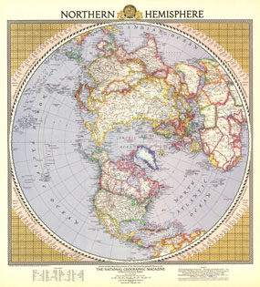
This colorful and unique map of the Northern Hemisphere appeared in National Geographic Magazine in February 1946 and features airline distances and U.S. air bases. European boundaries are shown as they were prior to Germany's invasion of Poland, and Russian boundaries reflect treaties and claims as of December 1, 1945.

The 1946 Northern Hemisphere map features:
• Mountain relief, deserts, and glaciers
• Russian boundaries according to treaties and claims as of December 1, 1945
• European boundaries as of January 1, 1938
• Principal U.S. air bases overseas and kickoff bases in the United States
• Airline distances across the Arctic, in the Americas, in the Pacific, and in the Atlantic
• Elevations and depths in feet
• Geographical equivalents

Coverage Area: Northern Hemisphere, North America, northern Africa, Europe, Asia

More Product Details

This map requires 7 business days to print and laminate prior to shipping.

Appearing in the February 1946 issue of the National Geographic Magazine, this Northern Hemisphere map has been reproduced from its original cartography in order to bring to life a beautiful poster previously only seen in National Geographic Magazine. This reproduction holds true to the high standards that National Geographic Maps are known for.

Perfect for home, office or classroom, this map also makes a great gift. Map collectors will surely want to add this map to their library.

The Paper version is printed on high quaility semi-gloss paper, perfect for framing.

The Laminated version uses 3mm laminate on both sides for durability, is easy to clean and markable.

From the National Geographic Classic Maps collection, this reproduction is just one of hundreds of titles available here. These maps are Printed on Demand. Sizes are approximate and may vary due to the nature of the trimming and laminating processes.
Shipping Conditions
Maps.com ships to Dometic US only

US FlagThis product can only be shipped to the Domestic U.S.A. (No APO's or PO Boxes)
TimeThis map requires 2 business days to print and laminate prior to shipping.