SHOP BY YEAR :: FOR OFFICE :: FOR CLASSROOM :: GIFT IDEAS :: CUSTOMER SERVICE

World Map 1965
Issue: February 1965
More Views
Enlarge Image
ZoomClick here to zoom!
Purchase Product :
Please select map format:
Laminated   
42" x 29.5" - $59.95
Laminated-w/Plastic Rails  (What are rails?)
42" x 29.5" - $76.95
Paper
42" x 29.5" - $49.95
Wallzilla Adhesive Format
42" x 29.5" - $89.95
Product Highlights
World Map 1965
Item#: X NGC 021965

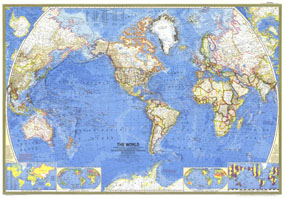
This stunning world map, first published in February of 1965, accompanied an article, entitled "Four-Ocean Navy in the Nuclear Age." In addtion to its beautiful colors and distinct National Geographic cartographic style, this world map includes detailed ocean depth and ocean currents information. Detailed geographical information and timely insets make this a classic map for any history buff. A perfect companion to the World maps published in 1943 and 1951.

The 1965 World map features:
• Classic National Geographic cartography and detail, with vivid country borders
• Thousands of place names, including country capitals
• International time zones, largest countries, major cities, vegetation and land use
• Insets showing the North Polar Region and South Polar Region
• An inset map showing the United Nations countries
• Insets for vegetation and land use, population density, and world time zones
• Airports, canals, depth curves and soundings in fathoms, elevations, prevailing winds, ocean currents, channel depths for principal ports

Coverage Area: The World, North America, South America, Africa, Asia, Australia, Europe, Oceania, Antarctica

More Product Details

This map requires 7 business days to print and laminate prior to shipping.

Appearing in the February 1965 issue of the National Geographic Magazine, this World map has been reproduced from its original cartography in order to bring to life a beautiful poster previously only seen in National Geographic Magazine. This reproduction holds true to the high standards that National Geographic Maps are known for.

Perfect for home, office or classroom, this map also makes a great gift. Map collectors will surely want to add this map to their library.

The Paper version is printed on high quaility semi-gloss paper, perfect for framing.

The Laminated version uses 3mm laminate on both sides for durability, is easy to clean and markable.

From the National Geographic Classic Maps collection, this reproduction is just one of hundreds of titles available here. These maps are Printed on Demand. Sizes are approximate and may vary due to the nature of the trimming and laminating processes.
Shipping Conditions
Maps.com ships to Dometic US only

US FlagThis product can only be shipped to the Domestic U.S.A. (No APO's or PO Boxes)
TimeThis map requires 2 business days to print and laminate prior to shipping.