SHOP BY YEAR :: FOR OFFICE :: FOR CLASSROOM :: GIFT IDEAS :: CUSTOMER SERVICE

Carte Generale Des Decouvertes De Lamiral De Fonte Map
Issue: February 1892
More Views
Enlarge Image
ZoomClick here to zoom!
Purchase Product :
Please select map format:
Laminated   
16" x 13" - $19.95
Laminated-w/Plastic Rails  (What are rails?)
16" x 13" - $29.95
Paper
16" x 13" - $14.95
Wallzilla Adhesive Format
16" x 13" - $34.95
Product Highlights
Carte Generale Des Decouvertes De Lamiral De Fonte Map
Item#: X NGC 021892

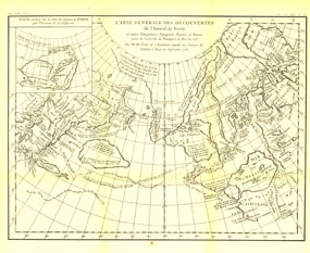
The "Carte Generale des Decouvertes de lapos; Amiral de Fonte" map is a black and white antique map created by Joseph-Nicolas De lapos;Isle in 1752 showing the supposed discoveries of Spanish explorer Admiral de la Fuente and the tracks of Spanish, English, and Russian navigators. These mythical "discoveries" included a Northwest Passage. Published in February 1892, it accompanied the article "The Cartography and Observations of Bering's First Voyage."

The 1892 "Carte Generale des Decouvertes de lapos; Amiral de Fonte" map features:
• Tracks of Spanish, English, and Russian navigators with the year of crossing noted

Coverage Area: Arctic regions, Siberia, northeastern Asia, northwestern North America

More Product Details

This map requires 7 business days to print and laminate prior to shipping.

Appearing in the February 1892 issue of the National Geographic Magazine, this Carte Generale Des Decouvertes De Lamiral De Fonte map has been reproduced from its original cartography in order to bring to life a beautiful poster previously only seen in National Geographic Magazine. This reproduction holds true to the high standards that National Geographic Maps are known for.

Perfect for home, office or classroom, this map also makes a great gift. Map collectors will surely want to add this map to their library.

The Paper version is printed on high quaility semi-gloss paper, perfect for framing.

The Laminated version uses 3mm laminate on both sides for durability, is easy to clean and markable.

From the National Geographic Classic Maps collection, this reproduction is just one of hundreds of titles available here. These maps are Printed on Demand. Sizes are approximate and may vary due to the nature of the trimming and laminating processes.
Shipping Conditions
Maps.com ships to Dometic US only

US FlagThis product can only be shipped to the Domestic U.S.A. (No APO's or PO Boxes)
TimeThis map requires 2 business days to print and laminate prior to shipping.