|
|
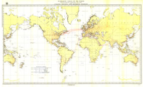
Submarine Cables Of The World Map
Issue: March 1896

|
|
|
|
|
|
|
| Product Highlights |
| Submarine Cables Of The World Map |
| Item#: X NGC 031896 |
Submarine cables have played an important part in the development of world-wide communications since the 1850s. This fascinating map, first develped for the Department of the Navy and published in National Geographic in 1896, shows submarine cables that had been laid, as well as the land-based cable systems that connected to them. The 1896 Submarine Cables of the World map features:
• Telegraph Cable lines for all of the major cables that had been laid in the world
• Principal connecting Land lines connected to the submarine lines
• Coaling facilities locations showing where ships could obtain fuel. Facilities were classified by the amount of coal they could provide to a single ship.
• Repair facilities showing where ships could be repaired. Facilities were classified according to the level of repair they could offer.
• Docking facilities, according to the size of ship that could be docked
Coverage Area:
|
|
More Product Details
This map requires 7 business days to print and laminate prior to shipping.
Appearing in the March 1896 issue of the National Geographic Magazine, this Submarine Cables Of The World map has been reproduced from its original cartography in order to bring to life a beautiful poster previously only seen in National Geographic Magazine. This reproduction holds true to the high standards that National Geographic Maps are known for.
Perfect for home, office or classroom, this map also makes a great gift. Map collectors will surely want to add this map to their library.
The Paper version is printed on high quaility semi-gloss paper, perfect for framing.
The Laminated version uses 3mm laminate on both sides for durability, is easy to clean and markable.
From the National Geographic Classic Maps collection, this reproduction is just one of hundreds of titles available here. These maps are Printed on Demand. Sizes are approximate and may vary due to the nature of the trimming and laminating processes.
|
|
Shipping Conditions
Maps.com ships to Dometic US only
 | This product can only be shipped to the Domestic U.S.A. (No APO's or PO Boxes) |  | This map requires 2 business days to print and laminate prior to shipping. |
|


 Click here to zoom!