SHOP BY YEAR :: FOR OFFICE :: FOR CLASSROOM :: GIFT IDEAS :: CUSTOMER SERVICE

Living On The Edge Map
Issue: April 1995
More Views
Enlarge Image
ZoomClick here to zoom!
Purchase Product :
Please select map format:
Laminated   
22" x 36" - $39.95
Laminated-w/Plastic Rails  (What are rails?)
22" x 36" - $51.95
Paper
22" x 36" - $29.95
Wallzilla Adhesive Format
22" x 36" - $59.95
Product Highlights
Living On The Edge Map
Item#: X NGC 041995b

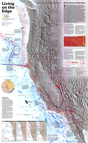
There is no escaping geology on the West Coast of the US. Earthquakes shake California continuallly. Volcanoes loom over northern California, Oregon, and Washington. Each of these hazards marks a different kind of plate boundary--a transform fault to the south, a subduction zone up north. This map shows the western US, along with all of the known major fault lines and zones.

The 1995 "Living on the Edge" map features:
• Active faults, faults not considered to be active, subduction zones
• Relief map of the western US, showing locations of faults, earthquakes, and volcanoes
• Volcanoes active in the past 10,000 years
• Earthquake epicenters, and earthquake magnitudes 1964-1994
• An inset explaining how the Transform Fault shaping much of the current California was formed

Coverage Area: Western US, California, Oregon, Washington, Baja California

More Product Details

This map requires 7 business days to print and laminate prior to shipping.

Appearing in the April 1995 issue of the National Geographic Magazine, this Living On The Edge map has been reproduced from its original cartography in order to bring to life a beautiful poster previously only seen in National Geographic Magazine. This reproduction holds true to the high standards that National Geographic Maps are known for.

Perfect for home, office or classroom, this map also makes a great gift. Map collectors will surely want to add this map to their library.

The Paper version is printed on high quaility semi-gloss paper, perfect for framing.

The Laminated version uses 3mm laminate on both sides for durability, is easy to clean and markable.

From the National Geographic Classic Maps collection, this reproduction is just one of hundreds of titles available here. These maps are Printed on Demand. Sizes are approximate and may vary due to the nature of the trimming and laminating processes.
Shipping Conditions
Maps.com ships to Dometic US only

US FlagThis product can only be shipped to the Domestic U.S.A. (No APO's or PO Boxes)
TimeThis map requires 2 business days to print and laminate prior to shipping.