 |
|
|
|
|
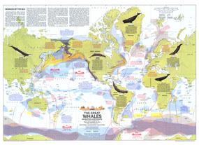
Great Whales, Migration And Range Map
Issue: December 1976
|
|
|
|
|
|
|
| Product Highlights |
| Great Whales, Migration And Range Map |
| Item#: X NGC 121976a |
The Great Whales map illustrates the migration and range of the six species of great whales including the Fin, Humpback, Sperm, Gray, Bowhead, and Right. Published in December 1976 with two articles on whales and the Whales of the World poster, this map contains information about how commercial whaling has decimated the populations of these magnificent mammals and the actions being taken to protect them. The 1976 Great Whales, Migration and Range map features:
• Shaded areas distinguishing the home waters of six species of the great whales
• Arrows indicating seasonal migration paths
• Information on the range, population and migratory habits of the six species of great whales
• Information on the countries that engage in whale hunting
• Shore whaling stations
• Floating factories catch and quota for 1975 and 1976
• Notes on tagging whales, whale watching, and more
Coverage Area: World
|
|
 |
More Product Details
This map requires 7 business days to print and laminate prior to shipping.
Appearing in the December 1976 issue of the National Geographic Magazine, this Great Whales, Migration And Range map has been reproduced from its original cartography in order to bring to life a beautiful poster previously only seen in National Geographic Magazine. This reproduction holds true to the high standards that National Geographic Maps are known for.
Perfect for home, office or classroom, this map also makes a great gift. Map collectors will surely want to add this map to their library.
The Paper version is printed on high quaility semi-gloss paper, perfect for framing.
The Laminated version uses 3mm laminate on both sides for durability, is easy to clean and markable.
From the National Geographic Classic Maps collection, this reproduction is just one of hundreds of titles available here. These maps are Printed on Demand. Sizes are approximate and may vary due to the nature of the trimming and laminating processes.
|
|
Shipping Conditions
Maps.com ships to Dometic US only
 | This product can only be shipped to the Domestic U.S.A. (No APO's or PO Boxes) |  | This map requires 2 business days to print and laminate prior to shipping. |
|
|
|
|


 Click here to zoom!