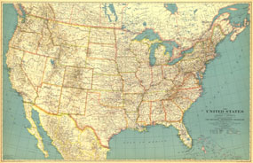
This beautiful US map, first published in May of 1933, accompanied a National Geographic article entitled, "How the United States Grew." Perhaps a sign of the times, the cartographers employed decidedly muted tones for the map. Wonderful typography and incredible attention to detail make this a map that is perfect for any collection. The 1993 United States and Adjoining Portions of Canada and Mexico map features:
• The US, southern Canada, and northern Mexico
• State and international boundaries
• Thousands of cities and towns, classified by their size according to the Census of 1930
• Highways and secondary roads
• Waterways, mountains and mountain ranges, national parks, and national monuments
• Beautiful typography accentuates the features of the map
Coverage Area: United States, southern Canada, northern Mexico
|


 Click here to zoom!
