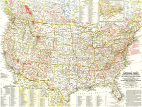
Discover the abundance and diversity of the lands, forests, memorials, and battle sites administered by the National Park Service. Published in May 1958 as half of a two-map presentation on national parks, this map also includes Canadian parks with an inset map of New Brunswick, Nova Scotia, and Prince Edward Island. The 1958 National Parks map side 1 features:
• National parks, forest, and monuments, including battlefield sites
• Canadian parks, including an inset map of New Brunswick, Nova Scotia, and Prince Edward Island
• Information on sites that the park service administers outside the United States, which at this time were sites in Alaska and Hawaii
• Information on National Geographics role in the preservation of some of these sites
• Thousands of cities and towns, including state capitals
• The Appalacian Trail
• Roads (both existing and under construction), freeways, and tollroads
Coverage Area: United States, southern Canada
|


 Click here to zoom!
