SHOP BY YEAR :: FOR OFFICE :: FOR CLASSROOM :: GIFT IDEAS :: CUSTOMER SERVICE

United States Of America Map 1946
Issue: July 1946
More Views
Enlarge Image
ZoomClick here to zoom!
Purchase Product :
Please select map format:
Laminated   
41" x 27" - $59.95
Laminated-w/Plastic Rails  (What are rails?)
41" x 27" - $76.95
Paper
41" x 27" - $49.95
Wallzilla Adhesive Format
41" x 27" - $89.95
Product Highlights
United States Of America Map 1946
Item#: X NGC 071946

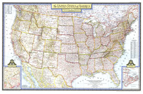
This beautiful United States map was published in the July, 1946 National Geographic Magazine. The map shows all the major highways of the time, and is rich in detail and cartographic excellence. An interesting inset shows the proposed area in which the as yet unlocated United Nations would find its permanent home.

The 1946 United States map features:
• Full coverage of the 48 states in 1946
• Southern Canada and northern Mexico
• Thousands of place names, including state capitals
• Major roads, rivers, lakes, mountain ranges and elevations
• An inset showing the area in which the Permanent Site Committee for the United Nations considered for the UN as its permanent site
• An inset listing the national parks and monuments, as keyed to the map
• An inset for the area of Canada east of Maine

Coverage Area: Continental United States, southern Canada, Northern Mexico

More Product Details

This map requires 7 business days to print and laminate prior to shipping.

Appearing in the July 1946 issue of the National Geographic Magazine, this United States Of America map has been reproduced from its original cartography in order to bring to life a beautiful poster previously only seen in National Geographic Magazine. This reproduction holds true to the high standards that National Geographic Maps are known for.

Perfect for home, office or classroom, this map also makes a great gift. Map collectors will surely want to add this map to their library.

The Paper version is printed on high quaility semi-gloss paper, perfect for framing.

The Laminated version uses 3mm laminate on both sides for durability, is easy to clean and markable.

From the National Geographic Classic Maps collection, this reproduction is just one of hundreds of titles available here. These maps are Printed on Demand. Sizes are approximate and may vary due to the nature of the trimming and laminating processes.
Shipping Conditions
Maps.com ships to Dometic US only

US FlagThis product can only be shipped to the Domestic U.S.A. (No APO's or PO Boxes)
TimeThis map requires 2 business days to print and laminate prior to shipping.