SHOP BY YEAR :: FOR OFFICE :: FOR CLASSROOM :: GIFT IDEAS :: CUSTOMER SERVICE

Deep South Map 1983 Side 2
Issue: August 1983
Deep South Map 1983 Side 2
More Views
Enlarge Image
Purchase Product :
Please select map format:
27" x 20"   
Laminated - $39.95
Paper - $29.95
Laminated-w/Plastic Rails  (What are rails?)
27" x 20" - $51.95
Product Highlights
Deep South Map 1983 Side 2
Item#: X NGC 081983b

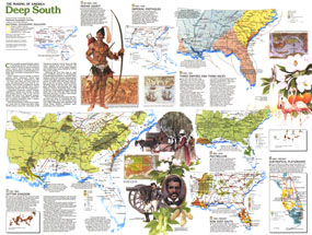
Part of the "Making of America" series, the Deep South map is half of a two-map set published in August 1984. With nine unique maps profiling the history of the region, this work provides an abundance of information on the cultures who settled the region, its dark history of slavery, phases of its economic growth, and more.

The 1983 Deep South map Side 2 features:
• A historical introduction
• Information on the Indian tribes of the region and early European settlements including Indian settlements, trade routes, missions, forts, and more
• Maps and historical overviews of the eras of slavery, cotton plantations, and the Seminole Wars
• A map showing the agriculture and industry in the region following the Civil War
• Maps of the areas of Black population higher than 50% in 1860 and 1980
• A map detailing Florida's development into a retirement center and tourist state
• Illustrations of historical figures and scenes

Coverage Area: Arkansas, Tennessee, North Carolina, South Carolina, Georgia, Florida, Alabama, Mississippi, Louisiana,

More Product Details

This map requires 2 business days to print and laminate prior to shipping.

Appearing in the August 1983 issue of the National Geographic Magazine, this Deep South map Side 2 has been reproduced from its original cartography in order to bring to life a beautiful poster previously only seen in National Geographic Magazine. This reproduction holds true to the high standards that National Geographic Maps are known for.

Perfect for home, office or classroom, this map also makes a great gift. Map collectors will surely want to add this map to their library.

The Paper version is printed on high quaility semi-gloss paper, perfect for framing.

The Laminated version uses 3mm laminate on both sides for durability, is easy to clean and markable.

From the National Geographic Classic Maps collection, this reproduction is just one of hundreds of titles available here. These maps are Printed on Demand. Sizes are approximate and may vary due to the nature of the trimming and laminating processes.
Shipping Conditions
Maps.com ships only to US & Canada

Canada FlagDeliveries to Canada are subject to Customs duties/brokerage fees upon arrival. This cost is not included in the product or shipping charges.
TimeThis map requires 2 business days to print and laminate prior to shipping.