SHOP BY YEAR :: FOR OFFICE :: FOR CLASSROOM :: GIFT IDEAS :: CUSTOMER SERVICE

Territorial Growth Of The United States Map 1987
Issue: September 1987
More Views
Enlarge Image
ZoomClick here to zoom!
Purchase Product :
Please select map format:
Laminated   
42" x 29" - $59.95
Laminated-w/Plastic Rails  (What are rails?)
42" x 29" - $76.95
Paper
42" x 29" - $49.95
Wallzilla Adhesive Format
42" x 29" - $89.95
Product Highlights
Territorial Growth Of The United States Map 1987
Item#: X NGC 091987b

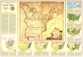
Explore the growth of the United States from the thirteen original colonies to its present range with the Territorial Growth of the United States map. Featuring eight individual insets higlighting historical periods, it also contains an antique map of the the country in 1783. Published in September 1987, this map is half of a two-map set, appearing with the map of the United States.

The 1987 Territorial Growth of the United States map features:
• Seven inset maps showing territorial growth from 1750 through 1987
• Early land claims, explorations, Spanish forts, and disputed areas
• Original thirteen states, selected Revolutionary War battle sites, and land claims in the late 18th century
• Information and map about the expansion west beyond the Mississippi
• Selected battle sites from the Seminole War, the War of 1812, the Mexican War, the Texas Revolution War, Indian Wars and the Civil War
• Inset showing the U.S. and its territories and exclusive economic zones today
• Historical overviews of the various periods shown

Coverage Area: United States, Alaska, Hawaii

More Product Details

This map requires 7 business days to print and laminate prior to shipping.

Appearing in the September 1987 issue of the National Geographic Magazine, this Territorial Growth Of The United States map has been reproduced from its original cartography in order to bring to life a beautiful poster previously only seen in National Geographic Magazine. This reproduction holds true to the high standards that National Geographic Maps are known for.

Perfect for home, office or classroom, this map also makes a great gift. Map collectors will surely want to add this map to their library.

The Paper version is printed on high quaility semi-gloss paper, perfect for framing.

The Laminated version uses 3mm laminate on both sides for durability, is easy to clean and markable.

From the National Geographic Classic Maps collection, this reproduction is just one of hundreds of titles available here. These maps are Printed on Demand. Sizes are approximate and may vary due to the nature of the trimming and laminating processes.
Shipping Conditions
Maps.com ships to Dometic US only

US FlagThis product can only be shipped to the Domestic U.S.A. (No APO's or PO Boxes)
TimeThis map requires 2 business days to print and laminate prior to shipping.