 |
|
|
|
|
United States Federal Lands Map 1996
Issue: October 1996
|
|
|
|
|
|
|
| Product Highlights |
| United States Federal Lands Map 1996 |
| Item#: X NGC 101996a |
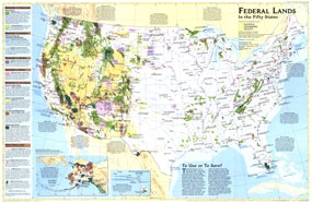
Considered by many to be the finest map of US federal lands ever published, this 1996 map shows the lands that are controlled by our federal agencies. Color coding shows the areas by agency. Descriptions of the types of federal lands make this an outstanding reference for anyone interested in how our federal lands are managed, and who manages them. The 1996 Federal Lands map features:
• A complete US map, overlayed with federal lands according to the agency in charge
• Overlays for the types of land controlled by the Departments of Agriculture, Commerce, Defense, Energy, Interior, and other federal lands
• Detailed descriptions of the types of federal land under the jurisdiction of each Department. Separate color coding is used to show the agencies within each Department, for instance within the Department of Interior are the Bureau of Indian Affairs, Bureau of Land Management, US Fish and Wildlife Service, and the National Park Service.
• Land areas under the jurisdiction of the National Parks, Forest Service, national grasslands, National Oceanic and Atmospheric Administration, national estuarine research, military reservations and installations, DOE research facilities, Indian reservations, BLM lands, national wildlife refuges, national recreation areas, national wild and scenic rivers, wilderness areas, and national scenic trails.
Coverage Area: United States
|
|
 |
More Product Details
This map requires 7 business days to print and laminate prior to shipping.
Appearing in the October 1996 issue of the National Geographic Magazine, this Federal Lands map has been reproduced from its original cartography in order to bring to life a beautiful poster previously only seen in National Geographic Magazine. This reproduction holds true to the high standards that National Geographic Maps are known for.
Perfect for home, office or classroom, this map also makes a great gift. Map collectors will surely want to add this map to their library.
The Paper version is printed on high quaility semi-gloss paper, perfect for framing.
The Laminated version uses 3mm laminate on both sides for durability, is easy to clean and markable.
From the National Geographic Classic Maps collection, this reproduction is just one of hundreds of titles available here. These maps are Printed on Demand. Sizes are approximate and may vary due to the nature of the trimming and laminating processes.
|
|
Shipping Conditions
Maps.com ships to Dometic US only
 | This product can only be shipped to the Domestic U.S.A. (No APO's or PO Boxes) |  | This map requires 2 business days to print and laminate prior to shipping. |
|
|
|
|


 Click here to zoom!