SHOP BY YEAR :: FOR OFFICE :: FOR CLASSROOM :: GIFT IDEAS :: CUSTOMER SERVICE

Map Showing Award of Alaska Boundary Tribunal 1896
Issue: January 1904
More Views
Enlarge Image
ZoomClick here to zoom!
Purchase Product :
Please select map format:
Laminated   
13" x 13" - $19.95
Laminated-w/Plastic Rails  (What are rails?)
13" x 13" - $29.95
Paper
13" x 13" - $14.95
Wallzilla Adhesive Format
13" x 13" - $34.95
Product Highlights
Map Showing Award of Alaska Boundary Tribunal 1896
Item#: X NGC 011904

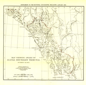
The "Map Showing Award of Alaska Boundary Tribunal, October 2, 1896" was drawn on October 20, 1903 and appeared in National Geographic Magazine in January 1904 with an article on the Alaska Boundary Tribunal. The boundary separating the Alaskan Panhandle from British Columbia had been in dispute for many years. A decision was finally reached in 1903 by a tribunal of U.S., Canadian, and British officials.

The Map Showing Award of Alaska Boundary Tribunal, October 2, 1896 features:
• The boundary between Alaska and British Columbia
• Mountains, glaciers, and rivers
• Geographical features such as capes, sounds, bays, canals, islands, and more

Coverage Area: Alaskan Panhandle, western British Columbia

More Product Details

This map requires 7 business days to print and laminate prior to shipping.

Appearing in the January 1904 issue of the National Geographic Magazine, this Map Showing Award of Alaska Boundary Tribunal, October 2, 1896 has been reproduced from its original cartography in order to bring to life a beautiful poster previously only seen in National Geographic Magazine. This reproduction holds true to the high standards that National Geographic Maps are known for.

The Paper version is printed on high quaility semi-gloss paper, perfect for framing.

The Laminated version uses 3mm laminate on both sides for durability, is easy to clean and markable.

From the National Geographic Classic Maps collection, this reproduction is just one of hundreds of titles available here. These maps are Printed on Demand. Sizes are approximate and may vary due to the nature of the trimming and laminating processes.
Shipping Conditions
Maps.com ships to Dometic US only

US FlagThis product can only be shipped to the Domestic U.S.A. (No APO's or PO Boxes)
TimeThis map requires 2 business days to print and laminate prior to shipping.