SHOP BY YEAR :: FOR OFFICE :: FOR CLASSROOM :: GIFT IDEAS :: CUSTOMER SERVICE

Northern Approaches Maine to the Maritimes Map 1985 Side 1
Issue: February 1985
More Views
Enlarge Image
ZoomClick here to zoom!
Purchase Product :
Please select map format:
Laminated   
27" x 20" - $39.95
Laminated-w/Plastic Rails  (What are rails?)
27" x 20" - $51.95
Paper
27" x 20" - $29.95
Wallzilla Adhesive Format
27" x 20" - $59.95
Product Highlights
Northern Approaches Maine to the Maritimes Map 1985 Side 1
Item#: X NGC 021985a

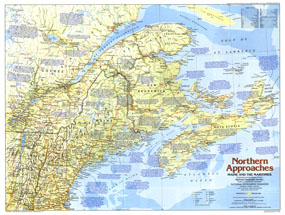
Explore Maine and the Maritimes with this educational map of the Northern Approaches. Published in February 1985 as part of the "Making of America" series, this map is Side One of a two map set. Home to colonies of English, French, Scottish, and Dutch settlers, this region of the United States and Canada boasts a fascinating and culturally rich maritime history.

The 1985 Northern Approaches Maine and the Maritimes map Side 1 features:
• An abundance of historical notes
• US national parks, Canadian national parks, Indian reservations or reserves, and sites
• State and provincial capitals, cities, and towns
• Ocean bathymetry, mountain relief, rivers, lakes, and swamps
• Interstate highways, roads, passenger railroads, and scheduled air service
• Mining areas and oil fields
• Geographical equivalents

Coverage Area: Maine, New Hampshire, Vermont, New Brunswick, Nova Scotia, Prince Edward Island, eastern Quebec

More Product Details

This map requires 7 business days to print and laminate prior to shipping.

Appearing in the February 1985 issue of the National Geographic Magazine, this Northern Approaches Maine to the Maritimes map has been reproduced from its original cartography in order to bring to life a beautiful poster previously only seen in National Geographic Magazine. This reproduction holds true to the high standards that National Geographic Maps are known for.

Perfect for home, office or classroom, this map also makes a great gift. Map collectors will surely want to add this map to their library.

The Paper version is printed on high quaility semi-gloss paper, perfect for framing.

The Laminated version uses 3mm laminate on both sides for durability, is easy to clean and markable.

From the National Geographic Classic Maps collection, this reproduction is just one of hundreds of titles available here. These maps are Printed on Demand. Sizes are approximate and may vary due to the nature of the trimming and laminating processes.
Shipping Conditions
Maps.com ships to Dometic US only

US FlagThis product can only be shipped to the Domestic U.S.A. (No APO's or PO Boxes)
TimeThis map requires 2 business days to print and laminate prior to shipping.