SHOP BY YEAR :: FOR OFFICE :: FOR CLASSROOM :: GIFT IDEAS :: CUSTOMER SERVICE

Northern Approaches Maine to the Maritimes Map 1985 Side 2
Issue: February 1985
More Views
Enlarge Image
ZoomClick here to zoom!
Purchase Product :
Please select map format:
Laminated   
27" x 20" - $39.95
Laminated-w/Plastic Rails  (What are rails?)
27" x 20" - $51.95
Paper
27" x 20" - $29.95
Wallzilla Adhesive Format
27" x 20" - $59.95
Product Highlights
Northern Approaches Maine to the Maritimes Map 1985 Side 2
Item#: X NGC 021985b

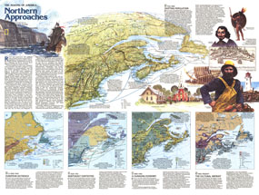
This map of the Northern Approaches represents Side Two of a two-map set published in February 1985 as part of the "Making of America" series. Highlighting the rich history of the Maritimes and New England, this educational map includes a physical relief map of the region, an abundance of historical information, and four inset maps representing particular historical periods.

The 1985 Northern Approaches Maine and the Maritimes map Side 2 features:
• An introduction to the early history of the region
• A map of the region ca 1000-1630 which includes tribal groups, indian villages, trading routes, missions, fisheries, whaling, and forts or trading stations
• The Northeast Contested map showing the region from 1630-1763 including French and English settlements and possessions, colonist and refugee routes, and industrial sites such as iron forges and shipyards
• A map detailing the region's changing economy from 1850-1950 including land use, natural resources, and declining and expanding manufacturing areas
• The Cultural Imprint map from 1950 to the present showing English-speaking and French-speaking areas, petroleum exploration areas, ski areas, resorts, and more
• A text overview of each historical period highlighted in the four maps
• Colorful illustrations

Coverage Area: Maine, New Hampshire, Vermont, Massachusetts, Connecticut, Rhode Island, New Brunswick, Nova Scotia, Prince Edward Island, Newfoundland, eastern Quebec

More Product Details

This map requires 7 business days to print and laminate prior to shipping.

Appearing in the February 1985 issue of the National Geographic Magazine, this Northern Approaches Maine to the Maritimes map has been reproduced from its original cartography in order to bring to life a beautiful poster previously only seen in National Geographic Magazine. This reproduction holds true to the high standards that National Geographic Maps are known for.

Perfect for home, office or classroom, this map also makes a great gift. Map collectors will surely want to add this map to their library.

The Paper version is printed on high quaility semi-gloss paper, perfect for framing.

The Laminated version uses 3mm laminate on both sides for durability, is easy to clean and markable.

From the National Geographic Classic Maps collection, this reproduction is just one of hundreds of titles available here. These maps are Printed on Demand. Sizes are approximate and may vary due to the nature of the trimming and laminating processes.
Shipping Conditions
Maps.com ships to Dometic US only

US FlagThis product can only be shipped to the Domestic U.S.A. (No APO's or PO Boxes)
TimeThis map requires 2 business days to print and laminate prior to shipping.