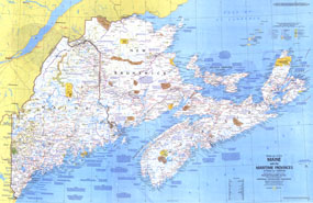
The "Maine, with Maritime Provinces of Close-up: Canada" map presents not only a detailed map of Maine, New Brunswick, Nova Scotia, and Prince Edward Island, but a wealth of notes about the festivals, events, and historical sites one can visit in this scenic region. Part of the "Close-up: U.S.A." series, this map was published in March 1975 with a companion travel poster and an article on Nova Scotia. The 1975 Maine, with the Maritime Provinces of Canada map features:
• Tourist activities and annual events noted
• National parks, state and provincial parks, wildlife refuges, national forests, Indian reservations, and more
• Recreational trails and recreational, scenic or wild rivers
• Capitals, cities, and towns
• Interstate highways, trans-Canada highway, other roads, passenger railroads, ferry routes, canals, and airports
• Subtle mountain relief, rivers, lakes, and swamps
• Ski areas
Coverage Area: Maine, New Brunswick, Nova Scotia, Prince Edward Island
|


 Click here to zoom!
