SHOP BY YEAR :: FOR OFFICE :: FOR CLASSROOM :: GIFT IDEAS :: CUSTOMER SERVICE

Texas Map 1986 Side 1
Issue: March 1986
More Views
Enlarge Image
ZoomClick here to zoom!
Purchase Product :
Please select map format:
Laminated   
27" x 20" - $39.95
Laminated-w/Plastic Rails  (What are rails?)
27" x 20" - $51.95
Paper
27" x 20" - $29.95
Wallzilla Adhesive Format
27" x 20" - $59.95
Product Highlights
Texas Map 1986 Side 1
Item#: X NGC 031986a

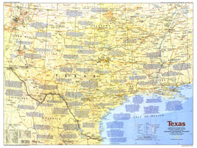
Half of a two-map set in the "Making of America" series, this Texas map was published in March 1986. It includes notes about key sites in the exciting history of the second largest state including information about its major cities.

The 1986 Texas map Side 1 features:
• An abundance of historical notes
• Capitals, cities, and towns
• National parks, Indian reservations, historic trail markers, missions, pueblos, mining areas, battlefields, ruins, and sites
• Interstate highways, major roads, other roads, passenger railroads, canals, and scheduled air service
• Major rivers, selected lakes, intermittent lakes, dry lakes, swamps, lava, and sand
• Mountain relief
• Ocean bathymetry, elevations and depth curves in meters

Coverage Area: Texas, Oklahoma, Arkansas, Mississippi, Louisiana, eastern New Mexico, northern Coahuila, northeastern Chihuahua, northern Nuevo Leon

More Product Details

This map requires 7 business days to print and laminate prior to shipping.

Appearing in the March 1986 issue of the National Geographic Magazine, this Texas map Side 1 has been reproduced from its original cartography in order to bring to life a beautiful poster previously only seen in National Geographic Magazine. This reproduction holds true to the high standards that National Geographic Maps are known for.

Perfect for home, office or classroom, this map also makes a great gift. Map collectors will surely want to add this map to their library.

The Paper version is printed on high quaility semi-gloss paper, perfect for framing.

The Laminated version uses 3mm laminate on both sides for durability, is easy to clean and markable.

From the National Geographic Classic Maps collection, this reproduction is just one of hundreds of titles available here. These maps are Printed on Demand. Sizes are approximate and may vary due to the nature of the trimming and laminating processes.
Shipping Conditions
Maps.com ships to Dometic US only

US FlagThis product can only be shipped to the Domestic U.S.A. (No APO's or PO Boxes)
TimeThis map requires 2 business days to print and laminate prior to shipping.