 |
|
|
|
|
Gold And Coal Fields Of Alaska Map 1898
Issue: April 1898
|
|
|
|
|
|
|
| Product Highlights |
| Gold And Coal Fields Of Alaska Map 1898 |
| Item#: X NGC 041898 |
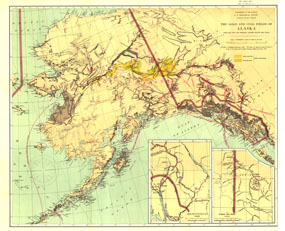
The Gold and Coal Fields of Alaska map appeared in National Geographic Magazine in April 1898 during the famous Klondike Gold Rush with the article "Alaska and Its Mineral Resources." This work also includes Canada's Klondike region and much of the Yukon Territory. A beautiful historical map and a must-have for collectors. The 1898 Gold and Coal Fields of Alaska Together with the Principal Steamer Routes and Trails map features:
• Inset of Trails from Tide Water to Headwaters of the Yukon River, Alaska
• Inset map of the Klondike Gold Region, Canada
• Gold bearing regions, Birch Creek series and Fortymile series, noted
• Gold and coal fields noted
• Monthly mail steamer routes
• Trails, camps, and rivers
• Fort St. Michael Military Reservation
Coverage Area: Alaska, western Yukon Territory
|
|
 |
More Product Details
This map requires 7 business days to print and laminate prior to shipping.
Appearing in the April 1898 issue of the National Geographic Magazine, this Gold And Coal Fields Of Alaska Together with the Principal Steamer Routes and Trails map has been reproduced from its original cartography in order to bring to life a beautiful poster previously only seen in National Geographic Magazine. This reproduction holds true to the high standards that National Geographic Maps are known for.
Perfect for home, office or classroom, this map also makes a great gift. Map collectors will surely want to add this map to their library.
The Paper version is printed on high quaility semi-gloss paper, perfect for framing.
The Laminated version uses 3mm laminate on both sides for durability, is easy to clean and markable.
From the National Geographic Classic Maps collection, this reproduction is just one of hundreds of titles available here. These maps are Printed on Demand. Sizes are approximate and may vary due to the nature of the trimming and laminating processes.
|
|
Shipping Conditions
Maps.com ships to Dometic US only
 | This product can only be shipped to the Domestic U.S.A. (No APO's or PO Boxes) |  | This map requires 2 business days to print and laminate prior to shipping. |
|
|
|
|


 Click here to zoom!