|
|
Alaska Map 1891
Issue: May 1891

|
|
|
|
|
|
|
| Product Highlights |
| Alaska Map 1891 |
| Item#: X NGC 051891 |
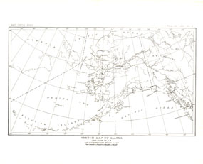
This antique sketch map of Alaska was published in 1891 with the article "The Southern Coast of Alaska." One of several early maps of what would become the 49th state in Union, this work makes a fine companion for the Muir Glacier map of 1892. The 1891 Alaska map features:
• Islands
• Rivers
• Juneau and Sitka noted
• Boundaries shown
Coverage Area: Alaska
|
|
More Product Details
This map requires 7 business days to print and laminate prior to shipping.
Appearing in the May 1891 issue of the National Geographic Magazine, this Alaska map has been reproduced from its original cartography in order to bring to life a beautiful poster previously only seen in National Geographic Magazine. This reproduction holds true to the high standards that National Geographic Maps are known for.
Perfect for home, office or classroom, this map also makes a great gift. Map collectors will surely want to add this map to their library.
The Paper version is printed on high quaility semi-gloss paper, perfect for framing.
The Laminated version uses 3mm laminate on both sides for durability, is easy to clean and markable.
From the National Geographic Classic Maps collection, this reproduction is just one of hundreds of titles available here. These maps are Printed on Demand. Sizes are approximate and may vary due to the nature of the trimming and laminating processes.
|
|
Shipping Conditions
Maps.com ships to Dometic US only
 | This product can only be shipped to the Domestic U.S.A. (No APO's or PO Boxes) |  | This map requires 2 business days to print and laminate prior to shipping. |
|


 Click here to zoom!