 |
|
|
|
|
Alaska Map 1956
Issue: June 1956
|
|
|
|
|
|
|
| Product Highlights |
| Alaska Map 1956 |
| Item#: X NGC 061956 |
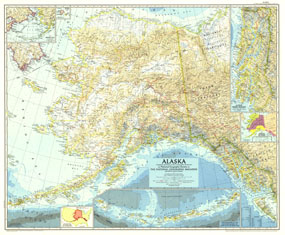
Published in June 1956 in the same year Alaska, then a territory of the United States, ratified its constitution, this map features several detailed insets of such areas as the Inside Passage and the Aleutian Islands. A relative size comparison of Alaska and the United States demonstrates that if the states westernmost point were superimposed on the California coast, its easternmost point would be on the east coast of South Carolina. The 1956 Alaska map features:
• Detailed inset of Alaskas Inside Passage and the Bering Sea
• Inset maps of the Diomede Islands and the continuation of the Aleutian Islands
• Relative size of Alaska and the United States, and judicial divisions
• Cities, towns, and abandoned or seasonally occupied settlements
• Northern and western limits of wooded country
• Ocean bathymetry and geographical features including mountains, rivers, lakes, passes, and glaciers and ice fields
• Highways, roads, roads under construction, railways, and places with scheduled air service
Coverage Area: Alaska
|
|
 |
More Product Details
This map requires 7 business days to print and laminate prior to shipping.
Appearing in the June 1956 issue of the National Geographic Magazine, this Alaska map has been reproduced from its original cartography in order to bring to life a beautiful poster previously only seen in National Geographic Magazine. This reproduction holds true to the high standards that National Geographic Maps are known for.
Perfect for home, office or classroom, this map also makes a great gift. Map collectors will surely want to add this map to their library.
The Paper version is printed on high quaility semi-gloss paper, perfect for framing.
The Laminated version uses 3mm laminate on both sides for durability, is easy to clean and markable.
From the National Geographic Classic Maps collection, this reproduction is just one of hundreds of titles available here. These maps are Printed on Demand. Sizes are approximate and may vary due to the nature of the trimming and laminating processes.
|
|
Shipping Conditions
Maps.com ships to Dometic US only
 | This product can only be shipped to the Domestic U.S.A. (No APO's or PO Boxes) |  | This map requires 2 business days to print and laminate prior to shipping. |
|
|
|
|


 Click here to zoom!