 |
|
|
|
|
State Of Alaska Map 1959
Issue: July 1959
|
|
|
|
|
|
|
| Product Highlights |
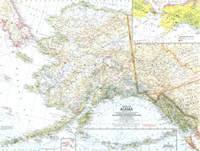
| State Of Alaska Map 1959 |
| Item#: X NGC 071959 |
The largest state in the United States, Alaska is also larger in area than all but 18 of the worlds nations. This map was published in July 1959 just six months after Alaska became the 49th state. The 1959 State of Alaska map feature:
• An inset showing vegetation and land use
• Inset maps of the Diomede Islands and the continuation of the Aleutian Islands
• Cities, towns, and abandoned or seasonally occupied settlements
• Northern and western limits of wooded country
• Ocean bathymetry and geographical features including mountains, rivers, lakes, passes, lava and glaciers and ice fields
• Roads, roads under construction, railroads, and places with scheduled air service
• Oil fields and pipelines
Coverage Area: Alaska
|
|
 |
More Product Details
This map requires 7 business days to print and laminate prior to shipping.
Appearing in the July 1959 issue of the National Geographic Magazine, this State Of Alaska map has been reproduced from its original cartography in order to bring to life a beautiful poster previously only seen in National Geographic Magazine. This reproduction holds true to the high standards that National Geographic Maps are known for.
Perfect for home, office or classroom, this map also makes a great gift. Map collectors will surely want to add this map to their library.
The Paper version is printed on high quaility semi-gloss paper, perfect for framing.
The Laminated version uses 3mm laminate on both sides for durability, is easy to clean and markable.
From the National Geographic Classic Maps collection, this reproduction is just one of hundreds of titles available here. These maps are Printed on Demand. Sizes are approximate and may vary due to the nature of the trimming and laminating processes.
|
|
Shipping Conditions
Maps.com ships to Dometic US only
 | This product can only be shipped to the Domestic U.S.A. (No APO's or PO Boxes) |  | This map requires 2 business days to print and laminate prior to shipping. |
|
|
|
|


 Click here to zoom!