|
|
Yellowstone And Grand Teton Map 1989 Side 2
Issue: February 1989

|
|
|
|
|
|
|
| Product Highlights |
| Yellowstone And Grand Teton Map 1989 Side 2 |
| Item#: X NGC 021989b |
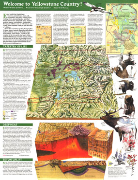
Published in February 1989 as half of a two-map presentation on the Yellowstone and Grand Teton parks, this educational map features information about the geological features of the region as well as facts about its wildlife. It appeared in the same issue as the article "Yellowstone: The Great Fires of 1988." The 1989 Yellowstone and Grand Teton map side 2 features:
• A physical relief map of the park
• Illustrations of and Information about the wildlife of the parks including management issues and threats to their numbers
• An inset map showing the ownership makeup of the area and boundaries
• Illustrations of cross-sections of the earth showing the subterranean makeup of the parks which produce the geysers, pools, and springs
• Interesting facts about the geological nature of the region including seismic activity and faults and fractures
• Information about the geological forces that formed the Grand Tetons
Coverage Area: Yellowstone National Park, Grand Teton National Park
|
|
More Product Details
This map requires 7 business days to print and laminate prior to shipping.
Appearing in the February 1989 issue of the National Geographic Magazine, this Yellowstone And Grand Teton map has been reproduced from its original cartography in order to bring to life a beautiful poster previously only seen in National Geographic Magazine. This reproduction holds true to the high standards that National Geographic Maps are known for.
Perfect for home, office or classroom, this map also makes a great gift. Map collectors will surely want to add this map to their library.
The Paper version is printed on high quaility semi-gloss paper, perfect for framing.
The Laminated version uses 3mm laminate on both sides for durability, is easy to clean and markable.
From the National Geographic Classic Maps collection, this reproduction is just one of hundreds of titles available here. These maps are Printed on Demand. Sizes are approximate and may vary due to the nature of the trimming and laminating processes.
|
|
Shipping Conditions
Maps.com ships to Dometic US only
 | This product can only be shipped to the Domestic U.S.A. (No APO's or PO Boxes) |  | This map requires 2 business days to print and laminate prior to shipping. |
|


 Click here to zoom!