 |
|
|
|
|
Battlefields Of The Civil War Map 1961
Issue: April 1961
|
|
|
|
|
|
|
| Product Highlights |
| Battlefields Of The Civil War Map 1961 |
| Item#: X NGC 041961a |
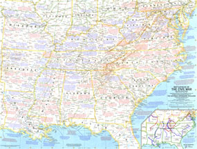
A must-have for civil war buffs, this map is based on a map on which General Grant marked his proposed lines of operation, and it portrays the country as it was charted in 1863. It was published in April 1961 with the article "The Civil War," and was the first half of a two-part collection of maps. The 1961 Battlefields of the Civil War map side 1 features:
• Inset map showing the major offensives
• Copious information about the war, officers, and specific battles
• Notes in blue describe events that occurred before April 1, 1863, while notes in red describe events following that date
• Hundreds of place names including state capitals, cities, towns, and forts
• Railroads and roads
• Geographical details including moutains, rivers, and islands
Coverage Area: southeastern United States
|
|
 |
More Product Details
This map requires 7 business days to print and laminate prior to shipping.
Appearing in the April 1961 issue of the National Geographic Magazine, this Battlefields Of The Civil War map has been reproduced from its original cartography in order to bring to life a beautiful poster previously only seen in National Geographic Magazine. This reproduction holds true to the high standards that National Geographic Maps are known for.
Perfect for home, office or classroom, this map also makes a great gift. Map collectors will surely want to add this map to their library.
The Paper version is printed on high quaility semi-gloss paper, perfect for framing.
The Laminated version uses 3mm laminate on both sides for durability, is easy to clean and markable.
From the National Geographic Classic Maps collection, this reproduction is just one of hundreds of titles available here. These maps are Printed on Demand. Sizes are approximate and may vary due to the nature of the trimming and laminating processes.
|
|
Shipping Conditions
Maps.com ships to Dometic US only
 | This product can only be shipped to the Domestic U.S.A. (No APO's or PO Boxes) |  | This map requires 2 business days to print and laminate prior to shipping. |
|
|
|
|


 Click here to zoom!