 |
|
|
|
|
Wisconsin, Michigan, And The Great Lakes Map 1973: Land Between the Waters
Issue: August 1973
|
|
|
|
|
|
|
| Product Highlights |
| Wisconsin, Michigan, And The Great Lakes Map 1973: Land Between the Waters |
| Item#: X NGC 081973b |
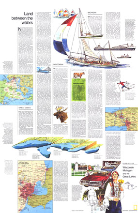
Part of the "Close-up: U.S.A." series, the "Wisconsin, Michigan, and the Great Lakes: Land Between the Waters" travel map is half of a two-map set, accompanied by the Wisconsin, Michigan, and the Great Lakes map. Published in August 1973, it contains inset maps of the Welland Canal and selected rivers as well as travel information and tips for motorists. The 1973 Wisconsin, Michigan, and the Great Lakes: Land Between the Waters map features:
• An introduction to the region
• Insets of the Detroit and St. Clair Rivers, St. Mary's River, and the Welland Canal
• An illustration of the Great Lakes showing their individual sizes, depths, and volumes
• Travel articles on Wisconsin, Michigan, and the Great Lakes
• Tips for motorists
• Colorful illustrations
Coverage Area: Wisconsin, Michigan, Great Lakes
|
|
 |
More Product Details
This map requires 7 business days to print and laminate prior to shipping.
Appearing in the August 1973 issue of the National Geographic Magazine, this Wisconsin, Michigan, and the Great Lakes: Land Between the Waters map has been reproduced from its original cartography in order to bring to life a beautiful poster previously only seen in National Geographic Magazine. This reproduction holds true to the high standards that National Geographic Maps are known for.
Perfect for home, office or classroom, this map also makes a great gift. Map collectors will surely want to add this map to their library.
The Paper version is printed on high quaility semi-gloss paper, perfect for framing.
The Laminated version uses 3mm laminate on both sides for durability, is easy to clean and markable.
From the National Geographic Classic Maps collection, this reproduction is just one of hundreds of titles available here. These maps are Printed on Demand. Sizes are approximate and may vary due to the nature of the trimming and laminating processes.
|
|
Shipping Conditions
Maps.com ships to Dometic US only
 | This product can only be shipped to the Domestic U.S.A. (No APO's or PO Boxes) |  | This map requires 2 business days to print and laminate prior to shipping. |
|
|
|
|


 Click here to zoom!