SHOP BY YEAR :: FOR OFFICE :: FOR CLASSROOM :: GIFT IDEAS :: CUSTOMER SERVICE

Central Plains Map Side 2 1985
Issue: September 1985
More Views
Enlarge Image
ZoomClick here to zoom!
Purchase Product :
Please select map format:
Laminated   
27" x 20" - $39.95
Laminated-w/Plastic Rails  (What are rails?)
27" x 20" - $51.95
Paper
27" x 20" - $29.95
Wallzilla Adhesive Format
27" x 20" - $59.95
Product Highlights
Central Plains Map Side 2 1985
Item#: X NGC 091985b

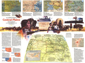
In four-hundred years the Great Plains of America shifted from a wild landscape of Bison and the Native American tribes who hunted them to the nation's breadbasket and agricultural heartland. Explore the region's colorful and often tragic history with the Central Plains map. Published in September 1985, this map represents Side Two of a two-map set in the "Making of America" series.

The 1985 Central Plains map Side 2 features:
• An abundance of historical information
• A map showing Indian relocation from 1830-1900
• Three maps of Indian territory from 1830 through 1906
• A map and information about the Dust Bowl
• Buffalo ranges, settlement areas in 1870, cattle trails, overland stage routes, pony express routes, railroads, telegraph lines, cow towns, and land offices
• Two maps showing the region's change from Indian land to frontier settlements
• Two maps showing immigration and agricultural growth of the region

Coverage Area: Nebraska, Iowa, Illinois, Missouri, Kansas, Oklahoma, Arkansas, eastern Colorado, eastern Wyoming

More Product Details

This map requires 7 business days to print and laminate prior to shipping.

Appearing in the September 1985 issue of the National Geographic Magazine, this Central Plains map Side 2 has been reproduced from its original cartography in order to bring to life a beautiful poster previously only seen in National Geographic Magazine. This reproduction holds true to the high standards that National Geographic Maps are known for.

Perfect for home, office or classroom, this map also makes a great gift. Map collectors will surely want to add this map to their library.

The Paper version is printed on high quaility semi-gloss paper, perfect for framing.

The Laminated version uses 3mm laminate on both sides for durability, is easy to clean and markable.

From the National Geographic Classic Maps collection, this reproduction is just one of hundreds of titles available here. These maps are Printed on Demand. Sizes are approximate and may vary due to the nature of the trimming and laminating processes.
Shipping Conditions
Maps.com ships to Dometic US only

US FlagThis product can only be shipped to the Domestic U.S.A. (No APO's or PO Boxes)
TimeThis map requires 2 business days to print and laminate prior to shipping.