SHOP BY YEAR :: FOR OFFICE :: FOR CLASSROOM :: GIFT IDEAS :: CUSTOMER SERVICE

Southwest Map 1982 Side 1
Issue: November 1982
More Views
Enlarge Image
ZoomClick here to zoom!
Purchase Product :
Please select map format:
Laminated   
27" x 20" - $39.95
Laminated-w/Plastic Rails  (What are rails?)
27" x 20" - $51.95
Paper
27" x 20" - $29.95
Wallzilla Adhesive Format
27" x 20" - $59.95
Product Highlights
Southwest Map 1982 Side 1
Item#: X NGC 111982a

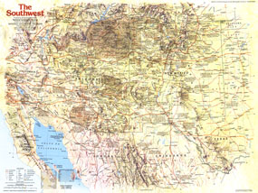
Published in November 1982, the Southwest map focuses on the states of Arizona and New Mexico, and their immediate neighbors. It contains a wealth of historical notes and points of interest including Indian reservations, ruins, missions, pueblos, and more. Part of the "Making of America" series, this map is half of a two-map set and accompanied four articles on the region including "The Anasazi - Riddles in the Ruins."

The 1982 Southwest map Side 1 features:
• An abundance of historical notes and information on points of interest
• National parks, Indian reservations, ruins, historic trail markers, missions, pueblos, battlefields, mining areas, and ghost towns
• Capitals, cities, and towns
• Interstate highways, major roads, paved roads, unpaved roads, railroads, and airports
• Mountains, passes, rivers, lakes, intermittent lakes, dry lakes, sand, and areas below sea level

Coverage Area: Arizona, New Mexico, northern Mexico, southeastern California, western Texas, southern Colorado, southern Utah

More Product Details

This map requires 7 business days to print and laminate prior to shipping.

Appearing in the November 1982 issue of the National Geographic Magazine, this Southwest map Side 1 has been reproduced from its original cartography in order to bring to life a beautiful poster previously only seen in National Geographic Magazine. This reproduction holds true to the high standards that National Geographic Maps are known for.

Perfect for home, office or classroom, this map also makes a great gift. Map collectors will surely want to add this map to their library.

The Paper version is printed on high quaility semi-gloss paper, perfect for framing.

The Laminated version uses 3mm laminate on both sides for durability, is easy to clean and markable.

From the National Geographic Classic Maps collection, this reproduction is just one of hundreds of titles available here. These maps are Printed on Demand. Sizes are approximate and may vary due to the nature of the trimming and laminating processes.
Shipping Conditions
Maps.com ships to Dometic US only

US FlagThis product can only be shipped to the Domestic U.S.A. (No APO's or PO Boxes)
TimeThis map requires 2 business days to print and laminate prior to shipping.