SHOP BY YEAR :: FOR OFFICE :: FOR CLASSROOM :: GIFT IDEAS :: CUSTOMER SERVICE

Egypts Nile Valley South Map 1995
Issue: January 1995
More Views
Enlarge Image
ZoomClick here to zoom!
Purchase Product :
Please select map format:
Laminated   
10" x 31" - $39.95
Laminated-w/Plastic Rails  (What are rails?)
10" x 31" - $51.95
Paper
10" x 31" - $29.95
Wallzilla Adhesive Format
10" x 31" - $59.95
Product Highlights
Egypts Nile Valley South Map 1995
Item#: X NGC 011995b

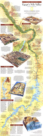
A must-have for anyone interested in archaeology or Egyptology, this fascinating map was published in January 1995 with an additional map of the northern Nile Valley. These fact-filled maps accompanied an article entitled "Age of the Pyramids: Egypts Old Kingdom." Both a modern map of the rich Nile Valley and a guide through Egypts magnificent past, this vibrant work features considerable details about archaeological sites and early Egyptian civilization.

The 1995 Egypts Nile Valley South map features:
• Modern cities, highways, railways, and airports
• An abundance of historical sites including submerged sites
• Insets of Thebes, Dandara, Karnak, Aswan Reach, and Abu Simbel
• Archaeological details of notable sites and the efforts made to protect them from degradation
• Facts about archaeological discoveries such as the Nag Hammadi codices
• Details of how the stones used to built the temples were mined, and quarry sites
• Insets of the Philae Temples and the Valley of Kings

Coverage Area: Egypts southern Nile Valley

More Product Details

This map requires 7 business days to print and laminate prior to shipping.

Appearing in the January 1995 issue of the National Geographic Magazine, this Egypts Nile Valley South map has been reproduced from its original cartography in order to bring to life a beautiful poster previously only seen in National Geographic Magazine. This reproduction holds true to the high standards that National Geographic Maps are known for.

The Paper version is printed on high quaility semi-gloss paper, perfect for framing.

The Laminated version uses 3mm laminate on both sides for durability, is easy to clean and markable.

From the National Geographic Classic Maps collection, this reproduction is just one of hundreds of titles available here. These maps are Printed on Demand. Sizes are approximate and may vary due to the nature of the trimming and laminating processes.
Shipping Conditions
Maps.com ships to Dometic US only

US FlagThis product can only be shipped to the Domestic U.S.A. (No APO's or PO Boxes)
TimeThis map requires 2 business days to print and laminate prior to shipping.