SHOP BY YEAR :: FOR OFFICE :: FOR CLASSROOM :: GIFT IDEAS :: CUSTOMER SERVICE

Africa Map 1909
Issue: March 1909
More Views
Enlarge Image
ZoomClick here to zoom!
Purchase Product :
Please select map format:
Laminated   
17" x 21.5" - $19.95
Laminated-w/Plastic Rails  (What are rails?)
17" x 21.5" - $29.95
Paper
17" x 21.5" - $14.95
Wallzilla Adhesive Format
17" x 21.5" - $34.95
Product Highlights
Africa Map 1909
Item#: X NGC 031909

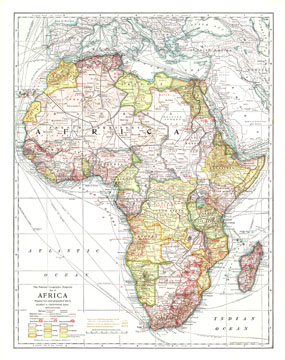
This historic map of Africa takes you back to 1909, a time when the "Dark Continent" was barely known in the outside world. A time when the only way to get to far off places like Abyssinia, the Congo State, and Bechuanaland Protectorate was to take a long sea voyage, then travel many miles by rail. National Geographic was among the first to bring this amazing land to the world, and this incredible map provides a time capsule into these times. Artistic cartography and painstaking detail make this a map for any collector.

The 1909 Africa map features:
• Country boundaries that show Independent Territories and Congo State, along with territories under control of Egypt, England, Germany, Spain, Italy, Turkey, France, and Portugal.
• Railroads in operation and those that were proposed
• Steamship lines, caravan routes, cable lines, telegraph lines
• Gold fields, silver fields, and diamond fields
• Ocean liner routes leading to African destinations from other parts of the world
• Principal products of each country or region are highlighted on the map
• Contour elevation lines in 500 foot increments

Coverage Area: Africa, Arabian Peninsula, Spain, Italy, Turkey and the Turkish Empire

More Product Details

This map requires 7 business days to print and laminate prior to shipping.

Appearing in the March 1909 issue of the National Geographic Magazine, this Africa map has been reproduced from its original cartography in order to bring to life a beautiful poster previously only seen in National Geographic Magazine. This reproduction holds true to the high standards that National Geographic Maps are known for.

Perfect for home, office or classroom, this map also makes a great gift. Map collectors will surely want to add this map to their library.

The Paper version is printed on high quaility semi-gloss paper, perfect for framing.

The Laminated version uses 3mm laminate on both sides for durability, is easy to clean and markable.

From the National Geographic Classic Maps collection, this reproduction is just one of hundreds of titles available here. These maps are Printed on Demand. Sizes are approximate and may vary due to the nature of the trimming and laminating processes.
Shipping Conditions
Maps.com ships to Dometic US only

US FlagThis product can only be shipped to the Domestic U.S.A. (No APO's or PO Boxes)
TimeThis map requires 2 business days to print and laminate prior to shipping.