SHOP BY YEAR :: FOR OFFICE :: FOR CLASSROOM :: GIFT IDEAS :: CUSTOMER SERVICE

Africa And The Arabian Peninsula Map 1950
Issue: March 1950
More Views
Enlarge Image
ZoomClick here to zoom!
Purchase Product :
Please select map format:
Laminated   
28" x 31" - $39.95
Laminated-w/Plastic Rails  (What are rails?)
28" x 31" - $51.95
Paper
28" x 31" - $29.95
Wallzilla Adhesive Format
28" x 31" - $59.95
Product Highlights
Africa And The Arabian Peninsula Map 1950
Item#: X NGC 031950

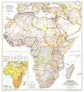
This intriguing historical snapshot of Africa and the Arabian Peninsula captures Libya and Somalias independence from colonial administration as well as early oil development in Saudi Arabia, Iraq, and Iran. First published in March 1950, this map accompanied three National Geographic articles including one entitled, "Roaming Africas Unfenced Zoos."

The 1950 Africa and the Arabian Peninsula map features:
• Country boundaries showing the Independent countries as well as colonial administration by Britain, France, Portugal, Belgium, Spain, and former Italian colonies
• United Nations Trusteeships
• Railways, roads, caravan routes, canals, and airports
• Locations of wells, ruins, and mountain passes
• Oil pipelines and oil fields
• Beautiful Physical Map inset of the continent which includes the sources of principal rivers
• Inset of the Cape Verde Islands

Coverage Area: Africa, Cape Verde Islands, Saudia Arabia, Iran, Iraq, Spain, Italy, Greece

More Product Details

This map requires 7 business days to print and laminate prior to shipping.

Appearing in the March 1950 issue of the National Geographic Magazine, this Africa And The Arabian Peninsula map has been reproduced from its original cartography in order to bring to life a beautiful poster previously only seen in National Geographic Magazine. This reproduction holds true to the high standards that National Geographic Maps are known for.

Perfect for home, office or classroom, this map also makes a great gift. Map collectors will surely want to add this map to their library.

The Paper version is printed on high quaility semi-gloss paper, perfect for framing.

The Laminated version uses 3mm laminate on both sides for durability, is easy to clean and markable.

From the National Geographic Classic Maps collection, this reproduction is just one of hundreds of titles available here. These maps are Printed on Demand. Sizes are approximate and may vary due to the nature of the trimming and laminating processes.
Shipping Conditions
Maps.com ships to Dometic US only

US FlagThis product can only be shipped to the Domestic U.S.A. (No APO's or PO Boxes)
TimeThis map requires 2 business days to print and laminate prior to shipping.