 |
|
|
|
|
Africa Threatened Map 1990
Issue: December 1990
|
|
|
|
|
|
|
| Product Highlights |
| Africa Threatened Map 1990 |
| Item#: X NGC 121990b |
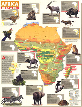
Africa began the 1970s with nearly 70,000 Black Rhinos and ended the 1980s with about 3,000. Their near extinction is but one illustration of the serious threats to African fauna detailed in this colorful and educational map. Published in December 1990 to accompany a detailed map of the continent and three articles including "A Gathering of Waters and Wildlife," this map is a must-have for animal lovers and those interested in the conservation of wildlife. The 1990 Africa Threatened map features:
• Thirteen striking insets of endangered and vulnerable wildlife including the Mountain Gorilla, Bannermans Turaco, Geometric Tortoise, African Elephant, and Black Rhinoceros
• Vulnerable species of Madagascar
• Insets illustrating human population and dominant land use
• Colorful and detailed vegetation key
• Protected areas shown as well as endangered and vulnerable species status
• Animal distribution showing present and former range
• Easy to read symbols for mammal, bird, and reptile or amphibian
Coverage Area: Africa and Madagascar
|
|
 |
More Product Details
This map requires 7 business days to print and laminate prior to shipping.
Appearing in the December 1990 issue of the National Geographic Magazine, this Africa Threatened map has been reproduced from its original cartography in order to bring to life a beautiful poster previously only seen in National Geographic Magazine. This reproduction holds true to the high standards that National Geographic Maps are known for.
Perfect for home, office or classroom, this map also makes a great gift. Map collectors will surely want to add this map to their library.
The Paper version is printed on high quaility semi-gloss paper, perfect for framing.
The Laminated version uses 3mm laminate on both sides for durability, is easy to clean and markable.
From the National Geographic Classic Maps collection, this reproduction is just one of hundreds of titles available here. These maps are Printed on Demand. Sizes are approximate and may vary due to the nature of the trimming and laminating processes.
|
|
Shipping Conditions
Maps.com ships to Dometic US only
 | This product can only be shipped to the Domestic U.S.A. (No APO's or PO Boxes) |  | This map requires 2 business days to print and laminate prior to shipping. |
|
|
|
|


 Click here to zoom!